
Why Mount Everest Trek Guide 2026 is on every trekker's list
There is a moment — somewhere above Lobuche, where the air thins and the glaciers gleam — when Everest stops being a name on a map and becomes something you feel in your chest. The Mount Everest trek to Base Camp is not just a walk in the mountains. It is a pilgrimage to the roof of the world, a journey through living Sherpa culture, ancient Buddhist monasteries, and landscapes so vast they recalibrate your sense of scale.
Everest Base Camp sits at 5,364 m above sea level. The classic round-trip route covers approximately 130 km, starting and ending at Lukla's legendary Tenzing-Hillary Airport (2,840 m). Along the way you will pass through the trading hub of Namche Bazaar, pause at the sacred Tengboche Monastery, and — if conditions allow — push to Kala Patthar (5,545 m) for the finest above-ground view of Everest's summit pyramid on the planet.
This guide covers everything: the route, a full 14–16 day itinerary, the best time to go, permits, costs in INR, what to pack, and how to stay safe at altitude. Bookmark it, share it, and come back to it as your departure date approaches.
Every year, tens of thousands of trekkers from around the world converge on Nepal's Khumbu Valley for one reason: Everest. For Indian trekkers specifically, EBC carries a magnetic pull. Nepal is visa-friendly, flight connections from Delhi, Mumbai, and Kolkata to Kathmandu are frequent, and the cultural familiarity of Hindu and Buddhist traditions makes the Khumbu region feel both exotic and oddly like home.
Here is why EBC consistently tops trekkers' bucket lists:
- No technical climbing required. Unlike summiting Everest itself — a serious mountaineering objective — trekking to Base Camp demands endurance and acclimatisation, not ropes or crampons.
- Unmatched scenery. Four of the world's six highest peaks (Everest, Lhotse, Makalu, Cho Oyu) are visible along the route.
- Sherpa culture. The Khumbu is the heartland of the Sherpa people. You will eat in family-run teahouses, visit gompas draped in prayer flags, and walk paths that generations of high-altitude climbers have followed.
- Sagarmatha National Park. A UNESCO World Heritage Site, the park protects snow leopards, Himalayan tahr, and red pandas alongside its extraordinary landscapes.
- Achievable for fit, motivated trekkers. With proper preparation, healthy adults can complete this trek without any mountaineering background.
The Nepal Tourism Board recorded over 50,000 trekking permits issued for the Sagarmatha region annually in recent years
At a glance
Ask TrekSage about Mount Everest Trek Guide 2026
Get instant answers grounded in verified trek data — beginner-friendliness, best months, permits, packing, and more.
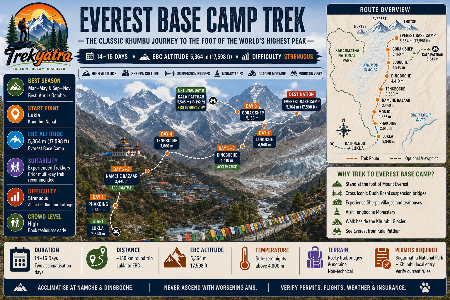
The route at a glance
The classic route follows a well-worn trail from Lukla northeast into the Khumbu Valley, ascending steadily through rhododendron forests, rocky moraines, and high-altitude plateaux before reaching the grey boulder field of Base Camp itself.
Elevation profile:
- Lukla (Tenzing-Hillary Airport): 2,840 m
- Phakding: 2,610 m (slight descent from Lukla)
- Namche Bazaar: 3,440 m
- Tengboche: 3,860 m
- Dingboche: 4,410 m
- Lobuche: 4,940 m
- Gorak Shep: 5,160 m
- Everest Base Camp: 5,364 m
- Kala Patthar (optional summit): 5,545 m
The route passes through Sagarmatha National Park, entering at the checkpoint gate near Monjo where your permits are inspected. The trail is non-technical but involves significant elevation gain, rocky paths, and several suspension bridge crossings over the Dudh Koshi River.
For a visual reference, consult a dedicated everest trek route map before departure — trail conditions and waypoints can shift seasonally.
Key Waypoints and Elevations
| Waypoint | Elevation | Approx. Distance from Previous Stop |
|---|---|---|
| Lukla (Tenzing-Hillary Airport) | 2,840 m | — (fly from Kathmandu) |
| Phakding | 2,610 m | ~8 km |
| Namche Bazaar | 3,440 m | ~11 km |
| Tengboche | 3,860 m | ~14 km |
| Dingboche | 4,410 m | ~10 km |
| Lobuche | 4,940 m | ~12 km |
| Gorak Shep | 5,160 m | ~6 km |
| Everest Base Camp | 5,364 m | ~6 km |
| Kala Patthar (optional) | 5,545 m | ~2 km from Gorak Shep |
All distances are approximate trail distances, not straight-line. Precise inter-stop distances may vary by 1–2 km depending on trail conditions and source.
What each day actually looks like
The itinerary below is structured for a 14–16 day round trip, including two mandatory acclimatisation days. Rushing this schedule significantly increases your risk of Acute Mountain Sickness (AMS).
Day 1 — Fly Kathmandu to Lukla; trek to Phakding (2,610 m)
The 35-minute flight from Kathmandu to Lukla's Tenzing-Hillary Airport is a thrill in itself — a short runway perched on a mountainside. Trek downhill through pine forests to Phakding alongside the Dudh Koshi River. (~3–4 hours trekking)
Day 2 — Phakding to Namche Bazaar (3,440 m)
A landmark day. Cross several suspension bridges, pass through the Sagarmatha National Park entrance at Monjo (permit check), and make the steep 600 m climb to Namche. First glimpses of Everest's peak may appear near the top. (~5–6 hours)
Day 3 — Acclimatisation Day at Namche Bazaar
Do not rest entirely — acclimatisation means hike high, sleep low. Walk up to the Everest View Hotel ridge (3,880 m) for panoramic views, visit the Sherpa Museum and the Saturday market. Return to Namche to sleep.
Day 4 — Namche Bazaar to Tengboche (3,860 m)
A classic day of trail through rhododendron and juniper forests with outstanding mountain views. Tengboche Monastery, the largest in the Khumbu, is the cultural highlight of the trek. (~5–6 hours)
Day 5 — Tengboche to Dingboche (4,410 m)
Descend to Pangboche, Nepal's highest permanently inhabited village, then climb into the wide glacial valley to Dingboche. The landscape becomes starker and more lunar. (~5–6 hours)
Day 6 — Acclimatisation Day at Dingboche
Hike up to Nangkartshang Peak (approx. 5,100 m) for views of Makalu, Lhotse, and Island Peak. This climb is physically demanding but critical for altitude adaptation. Return to Dingboche to sleep.
Day 7 — Dingboche to Lobuche (4,940 m)
The trail passes the Thukla memorial — stone cairns for climbers lost on Everest — before climbing steeply to Lobuche on the edge of the Khumbu Glacier moraine. (~5–6 hours)
Day 8 — Lobuche to Gorak Shep (5,160 m); continue to EBC (5,364 m)
The day most trekkers have trained months for. Walk across the glacier moraine to Gorak Shep, drop your pack, and push to Base Camp. The camp itself is a boulder field at the foot of the Khumbu Icefall — no summit views, but the sense of arrival is overwhelming. (~7–8 hours total)
Day 9 — Kala Patthar (5,545 m); descend to Pheriche (4,243 m)
An early pre-dawn start for Kala Patthar — arguably the finest viewpoint of Everest, Nuptse, and Lhotse available without technical climbing. Descend all the way to Pheriche for lower-altitude rest. (~7–8 hours)
Days 10–14 — Return to Lukla
The return generally follows the same trail in reverse but moves faster with altitude loss. A sample return schedule:
- Day 10: Pheriche → Namche Bazaar
- Day 11: Namche Bazaar → Lukla
- Day 12: Buffer day in Lukla (flights frequently delayed by weather)
- Days 13–14: Fly Lukla → Kathmandu; rest or departure
Note: Some operators route the return via Phortse and Khumjung for variety. Add 1–2 days for this option.
Acclimatisation Days Explained
Acclimatisation days are not optional rest days — they are physiologically essential. Above 3,000 m, your body needs time to produce additional red blood cells and adjust its respiratory rate. Skipping acclimatisation is the leading cause of emergency helicopter evacuations on the Everest trail.
Namche Bazaar (3,440 m): The first acclimatisation stop. Most trekkers feel fine here, which creates a false sense of security. The hike to the Everest View Hotel ridge tests your body at nearly 3,900 m before you sleep lower.
Dingboche (4,410 m): The second critical acclimatisation stop. At this elevation, altitude sickness becomes a serious risk. The Nangkartshang hike pushes you briefly to ~5,100 m before you return to sleep at 4,410 m — the classic "climb high, sleep low" protocol.
For a deeper dive into altitude physiology, see our guide to altitude sickness prevention tips.
When to go
Choosing the right season can make the difference between a life-changing experience and a weather-battered slog.
Spring (March–May) — Peak Season
This is the most popular window for good reason. Temperatures are mild, skies are generally clear, rhododendrons paint the lower valleys pink and red, and the high routes are snow-free. The downside: teahouses fill up quickly, especially in October and April. Book accommodation in advance. Late May brings pre-monsoon haze.
Monsoon (June–August) — Generally Avoid
Heavy rainfall, leeches on lower trails, poor mountain visibility, and landslide risk on access roads make monsoon trekking inadvisable for most. Some experienced trekkers do it for solitude, but you may see very little of the mountains you came for.
Autumn (September–November) — Second-Best Season
Post-monsoon clarity produces some of the sharpest mountain views of the year. October is statistically the most popular single month for EBC trekking. Temperatures drop sharply by November, especially at night above 4,000 m, but conditions remain safe for well-equipped trekkers.
Winter (December–February) — Experienced Only
Temperatures at Gorak Shep can plunge to -20°C or lower. Trails are icy, some teahouses close, and flight cancellations increase. That said, the trails are virtually empty and the skies often brilliantly clear. Only recommended for seasoned cold-weather trekkers.
Bottom line for 2026: Target October for optimal weather and views, or April for blooming landscapes and slightly smaller crowds than October. For more detail, see our best time to trek in Nepal guide.
Is this trek right for you?
Grade: Strenuous
The Everest Base Camp trek is not a casual walk. Daily trekking of 5–7 hours covering 10–15 km at progressively higher altitude is physically demanding even for fit adults. The terrain itself — mostly rocky trails with some steep ascents — is non-technical: no ropes, no crampons, no glacial crossings (on the standard route). The primary challenge is altitude, not technicality.
Who can do it:
- Healthy adults, broadly aged 18–60 (older trekkers do complete it with good fitness and medical clearance)
- Prior trekking experience is strongly recommended — if you have never trekked multi-day in the mountains, start with a shorter Himalayan trek first
- No summit climbing or mountaineering skills required
Recommended fitness preparation (3 months minimum):
- Cardiovascular exercise 3× per week (running, cycling, swimming)
- Stair climbing or incline treadmill with a loaded pack (8–12 kg)
- Weekend day hikes of increasing duration
- Core and leg strength training
If you have any pre-existing cardiac, respiratory, or blood pressure conditions, consult your physician before committing to this trek. Altitude affects everyone differently regardless of general fitness.
What permits you need
You need three key documents to legally trek the Everest Base Camp route in 2026:
1. Nepal Tourist Visa
Available on arrival at Tribhuvan International Airport, Kathmandu, or via Nepal's e-visa portal. Indian nationals do not require a visa for Nepal — but you do need a valid passport or voter ID card. (Indian nationals' exact entry document requirements — verify with Nepal Embassy 2026 regulations before travel.)
2. Sagarmatha National Park Entry Permit
Issued by the Nepal Tourism Board at their Kathmandu offices (Bhrikuti Mandap) or at the park entry checkpoint in Monjo.
- Cost: approximately NPR 3,000 (~INR 1,900) per person
- Required documents: passport photos, copy of passport/visa, permit application form
3. Khumbu Pasang Lhamu Rural Municipality Entry Permit
A local government permit introduced in recent years to channel tourism revenue to the Khumbu community.
- Cost: approximately NPR 2,000 (~INR 1,270) per person
- Issued at the municipal office in Lukla or Monjo
TIMS Card (Trekkers' Information Management System):
As of recent seasons, the TIMS card requirement for the Everest region has been in a state of flux — some operators report it is not separately required if you have the above permits.
Where to obtain permits: The Sagarmatha National Park permit can be arranged in Kathmandu before your Lukla flight — recommended to avoid delays at the gate. Both permits can also be obtained at Monjo checkpoint. Carry multiple passport-sized photos and copies of your documents.
What this trek will cost you
All figures below are approximate 2026 estimates in INR. Exchange rates fluctuate — verify current NPR/INR rates before departure.
DIY (Independent) Cost Breakdown:
| Item | Estimated Cost (INR) |
|---|---|
| Flights: Kathmandu–Lukla return | 25,000–35,000 |
| Permits (SNP + Khumbu) | ~3,200 |
| Teahouse accommodation (14–16 nights) | 5,000–13,000 |
| Food on trail (14–16 days) | 9,000–20,000 |
| Guide (if hired, per day × 14 days) | 35,000–56,000 |
| Porter (if hired, per day × 10 days) | 15,000–25,000 |
| Gear, insurance, miscellaneous | 15,000–30,000 |
| DIY total (without guide/porter) | ~80,000–1,20,000 |
| DIY total (with guide + porter) | ~1,20,000–1,80,000 |
Organised Package (from Indian operators): INR 1,20,000–2,00,000 per person, typically including Kathmandu–Lukla flights, teahouse accommodation, all meals on trail, licensed guide, porter, permits, and airport transfers. Does not usually include international flights or travel insurance.
Teahouse Accommodation Costs Along the Route
Teahouses (locally called lodges or guesthouses) are the backbone of Everest trail hospitality. Rooms are simple — usually a twin or single with basic bedding — and bathrooms are often shared. Hot showers (if available) cost extra.
| Location | Approx. Room Cost/Night (INR) | Notes |
|---|---|---|
| Phakding | 300–500 | Good variety of lodges |
| Namche Bazaar | 500–800 | Best amenities on route; Wi-Fi available |
| Tengboche | 400–600 | Limited options; book ahead in Oct/Apr |
| Dingboche | 400–700 | Several teahouses; solar-powered charging |
| Lobuche | 400–600 | Basic; cold nights |
| Gorak Shep | 500–800 | Most basic; highest teahouses on route |
Tip: Many teahouses offer free or discounted rooms if you commit to eating all meals at their dining hall. This is standard practice and worth accepting — food quality is broadly similar across lodges at the same elevation.
Peak season (October, April) teahouses fill fast. If travelling independently, carry a booking confirmation or arrive early each day. For more advice, see our Namche Bazaar acclimatisation guide.
What to pack
Packing smart is packing light — but not at the cost of safety. Use a porter (recommended) for your main duffel bag (max 15 kg) and carry a 25–30 L daypack yourself. For a detailed review of gear, see our what to pack for Himalayan trek guide.
Clothing (Layering System)
- Moisture-wicking base layers (top and bottom) × 2 sets
- Mid-layer fleece jacket
- Down jacket (600-fill or higher for above 4,000 m)
- Hardshell waterproof/windproof jacket
- Trekking pants × 2 pairs
- Thermal leggings
- Waterproof over-trousers
- Warm gloves (inner liner + outer shell)
- Balaclava
- Warm hat (wool or fleece)
- Neck buff × 2
- Merino wool socks × 4–5 pairs
- Light camp clothes for evenings
Footwear
- Waterproof leather or synthetic trekking boots (broken in before the trek). See our best trekking boots India guide.
- Gaiters (especially for late autumn/winter)
- Camp sandals or lightweight shoes
Gear
- Trekking poles (collapsible, with snow baskets)
- Headlamp with spare batteries
- Sleeping bag rated to -15°C (teahouses provide blankets but a quality bag is essential above 4,000 m)
- Daypack (25–30 L) with rain cover
- Duffel bag for porter load
- Sunglasses (UV400, category 3–4)
- Water bottles × 2 (1 L each) — avoid single-use plastic
Health and Safety
- Diamox (Acetazolamide) — consult your doctor before taking; typically 125–250 mg twice daily as a preventive
- Pulse oximeter (essential — monitor blood oxygen saturation)
- First-aid kit: blister pads, antiseptic, bandages, paracetamol, ibuprofen, oral rehydration salts
- Water purification tablets or SteriPen filter
- Sunscreen SPF 50+ (UV intensity is extreme at altitude)
- Lip balm SPF 30+
- Altitude sickness reference card
Documents
- Passport (and voter ID for Indian nationals)
- All trek permits
- Travel insurance documents (policy number + emergency helpline)
- Emergency contacts list (family, guide, nearest clinic)
- Passport photos × 6 (for permits)
Staying safe on the mountain
Altitude Sickness: Know Before You Go
Altitude sickness is the primary medical risk on the Everest trek. It can affect anyone regardless of age, fitness level, or prior altitude experience. Understanding it is non-negotiable.
Acute Mountain Sickness (AMS) — most common form:
- Symptoms: persistent headache, nausea, dizziness, fatigue, poor sleep, loss of appetite
- Onset: usually within 6–12 hours of arriving at a new altitude
- Treatment: rest at current altitude; descend if symptoms persist or worsen
High Altitude Cerebral Oedema (HACE) — severe AMS where fluid accumulates in the brain:
- Symptoms: severe headache unresponsive to paracetamol, confusion, loss of coordination, inability to walk straight
- Treatment: immediate descent + supplemental oxygen + Dexamethasone (medical emergency)
High Altitude Pulmonary Oedema (HAPE) — fluid in the lungs; most common cause of altitude-related death:
- Symptoms: breathlessness at rest, persistent cough (possibly with pink/frothy sputum), extreme fatigue, blue lips
- Treatment: immediate descent + supplemental oxygen (medical emergency — do not wait)
The golden rules:
1. Acclimatise properly — follow the "climb high, sleep low" principle
2. Hydrate — 3–4 litres of water per day
3. Ascend slowly — do not exceed 300–500 m of net elevation gain per day above 3,000 m
4. Never ignore symptoms — AMS can escalate to HACE or HAPE within hours
5. Descend immediately if severe symptoms appear — no view is worth your life
Diamox (Acetazolamide): Commonly prescribed as a preventive and treatment for AMS. Typical preventive dose is 125 mg twice daily, starting 24 hours before ascent. It has side effects (tingling fingers, increased urination) and is contraindicated with sulfa allergies. Consult a doctor before use.
Emergency contacts:
- Himalayan Rescue Association (HRA) Pheriche clinic: +977-1-4440292
- Your country's embassy in Kathmandu
- Your travel insurance emergency line (carry this on your person at all times)
Helicopter rescue: Available from most points on the trail but expensive without insurance. Always arrange travel insurance before departure. See our travel insurance for Himalayan treks guide.
Weather emergencies: Snowstorms and sudden whiteouts can occur even in peak season above 4,500 m. Carry emergency snacks, a whistle, and a foil space blanket. Never trek alone in poor visibility.
Travel Insurance: What Your Policy Must Cover
Do not trek to EBC without comprehensive travel insurance. Ensure your policy explicitly covers:
- Helicopter evacuation from high altitude (above 5,000 m) — this is the critical one; many standard policies exclude it
- Emergency medical treatment in Nepal and medical repatriation to India
- Trip cancellation and delay (Lukla flights cancel frequently due to weather)
- Lost or damaged gear
Recommended minimum coverage: Medical expenses of at least USD 100,000 (~INR 84,00,000) and evacuation coverage of at least USD 50,000 (~INR 42,00,000).
Check the fine print: some policies require that helicopter evacuation be authorised by the insurer before it is arranged. Save your insurer's 24-hour emergency number in your satellite messenger or trek phone.
Similar treks to explore
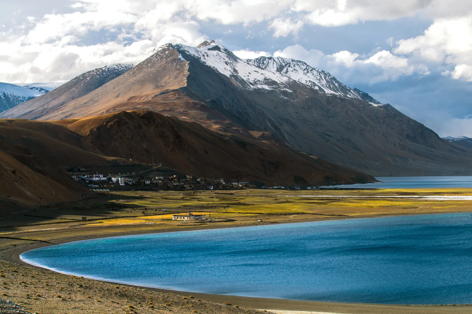
Rumtse to Tso Moriri Trek: Complete Ladakh Trail Guide
The Rumtse to Tso Moriri trek is an ~80 km, 7–8 day strenuous Ladakh trail crossing Kyamar La (~5,460 m) and Polokongka La (~5,190 m), ending at Tso Moriri Lake
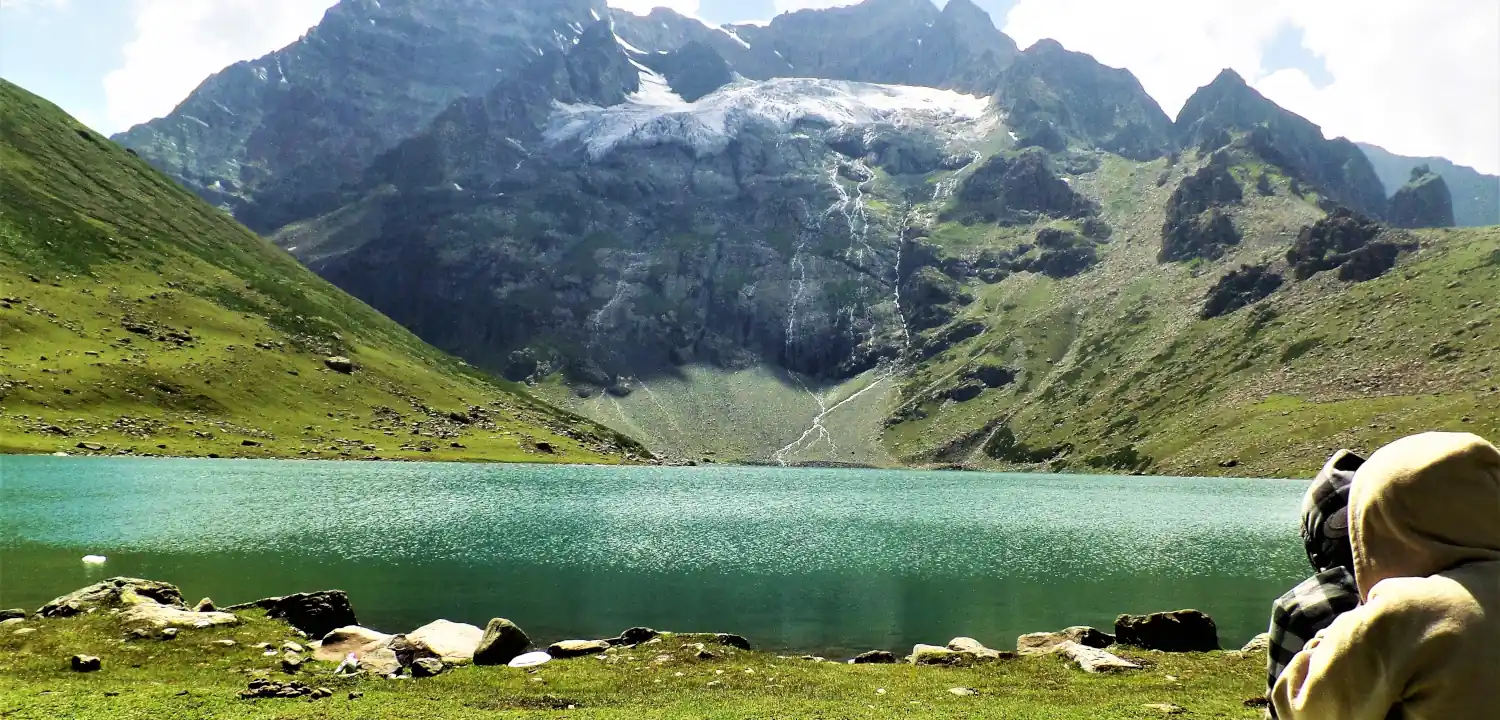
Naranag Gangabal Trek: Complete Guide (2026)
The Naranag Gangabal Trek is a 4–5 day moderate-difficult alpine trek in Kashmir, covering ~26–30 km from Naranag (2,150 m) to Gangabal Lake (3,570 m).
Kolahoi Glacier Trek: Complete Kashmir Guide 2026
The Kolahoi Glacier Trek is a moderate-to-challenging 6-day route from Aru Valley near Pahalgam to Kashmir's largest glacier at 4,100 m.
Common questions answered
EBC is classified as strenuous. The terrain — rocky trails, suspension bridges, moraine fields — is non-technical: you need no ropes, crampons, or climbing skills. The real challenge is sustained high altitude. Above 3,500 m, your body works significantly harder to extract oxygen from every breath. First-timers with prior trekking experience (multi-day hill treks in India, for instance) and 3 months of consistent cardio training fare well. Complete beginners may find it overwhelming; a shorter acclimatisation trek in Nepal or Himachal Pradesh before EBC is worth considering.
Mount Everest — Latest News
This Rescue Cat Has Climbed Colorado’s 14-ers. Now He Is Headed for Everest Base Camp.
A rescue cat has summited Colorado peaks and is now trekking to Everest Base Camp. Learn what this means for your Nepal trekking preparation.
After her nine-to-five, this 58-year-old from Chennai chases the mountains
After her nine-to-five, this 58-year-old from Chennai chases the mountains thehindu.com
Human Urine and Fuel Are Melting the Glacier Beneath Everest Base Camp
Human urine and fuel spills are melting Everest's glaciers faster. Learn what trekkers must do to protect the mountain and ensure future access.
Live Conditions
Real-time weather & trail status
Trail Conditions
Crowdsourced reports from trekkers who've done this route
Sign in to add a trip report
Find a Trek Buddy
Connect with trekkers planning the same route
No buddies yet for this trek
Sign in and be the first to post a planning signal.