Why Chanderkhani Pass Trek is on every trekker's list
The Chanderkhani Pass trek is a 4-day Easy-to-Moderate Himalayan trek in Kullu, Himachal Pradesh, reaching 3,660 m (12,008 ft) — best done May–June or September–October.
Tucked away in the Kullu district of Himachal Pradesh, the Chanderkhani Pass trek is one of those rare Himalayan journeys that rewards you with big-mountain drama without demanding technical climbing skills. Reaching a high point of approximately 3,660 metres (12,008 ft) above sea level, the pass sits on the ridge separating the Kullu Valley from the Malana nala, offering jaw-dropping views of the Pir Panjal range, Deo Tibba, and the sweeping Beas River valley far below.
While Hampta Pass grabs most of the headlines for Manali-area treks, the Chanderkhani Pass trek remains blissfully uncrowded — a genuine hidden gem accessible in just one hour from Manali. Whether you are a first-timer looking for your first real Himalayan experience or a seasoned trekker craving solitude, this route delivers.
This guide covers everything you need to plan your 2026 trek: the route, a day-wise itinerary, best time to visit, permits, costs, packing list, and safety tips.
In a region overflowing with trekking options, Chanderkhani earns its place for several compelling reasons.
Panoramic Himalayan views — From the pass, on a clear day you can identify towering peaks including Deo Tibba (6,001 m), Indrasan (6,221 m), and the entire arc of the Pir Panjal range. The Kullu Valley laid out thousands of metres below you is a view that stops even veteran trekkers mid-stride.
Ancient folklore — Local tradition links the pass to the era of the Mahabharata, with stories of the Pandavas crossing these ridges during their exile. Whether or not you subscribe to the legend, the mythology adds a layer of cultural depth that distinguishes Chanderkhani from purely scenic treks.
Off-the-beaten-path solitude — Compared to the increasingly crowded Hampta Pass trek, Chanderkhani sees a fraction of the footfall. You are far more likely to share your campsite with grazing horses than other trekking groups.
Accessibility from Manali — The trailhead at Naggar is just 30 km from Manali, making this one of the most logistically convenient high-altitude treks in the region. See our best treks near Manali list for context.
Varied terrain — The trail moves through oak and rhododendron forests, open grassland meadows, boulder fields, and finally a snow-dusted ridgeline — all within 28–32 km round trip. This variety keeps each day feeling fresh.
Beginner-friendly — Rated Easy-to-Moderate, the trek requires no technical skills. A reasonable fitness level and one acclimatisation day in Manali are the main prerequisites.
At a glance
The route at a glance
The standard route follows a linear path from Naggar village up through Rumsu and Naya Tapru to the pass, with a return along the same ridge or an alternate exit toward Malana village.
Standard route: Naggar → Rumsu → Naya Tapru → Chanderkhani Pass → return to Naggar
Total round-trip distance: approximately 28–32 km
Elevation gain: ~1,860 m from trailhead to pass
The Malana village side trail offers an alternate exit for those who want a point-to-point experience: after summiting the pass, descend into the Malana nala and exit to the road at Jari. This requires pre-arranged transport and adds logistical complexity, but rewards you with a visit to the famously insular Malana village.
Trek Distance and Altitude Profile
| Waypoint | Altitude | Distance from Previous Point |
|---|---|---|
| Naggar (trailhead) | 1,800 m (5,906 ft) | — |
| Rumsu village | 2,000 m (6,562 ft) | ~6 km |
| Naya Tapru meadow | 2,900 m (9,514 ft) | ~8 km |
| Chanderkhani Pass | 3,660 m (12,008 ft) | ~5 km |
Total ascent (one way): ~1,860 m
Total descent (return): ~1,860 m
⚠️Distances between waypoints are approximate and can vary slightly depending on trail conditions and the exact path taken. Verify with the Kullu Forest Division or a local guide before departure.
How Do I Reach the Chanderkhani Pass Trek Starting Point from Manali?
Naggar is the gateway to this trek, located approximately 30 km south of Manali on the left bank of the Beas River. The drive takes roughly 1 hour by road.
- Shared taxi: The most convenient option. Shared taxis from Manali's old bus stand to Naggar typically cost ₹100–200 per seat (2026 estimate; verify locally). A private cab will cost ₹500–800 one way.
- HRTC bus: Himachal Road Transport Corporation operates buses from Manali to Naggar with reasonable frequency during the trekking season. Check current schedules at the Manali HRTC depot — fares are lower than taxis but journey times are longer.
- Landmark: The iconic Naggar Castle — a 16th-century stone-and-wood fort now converted into a heritage hotel — is right at the village centre and serves as your orientation point.
- Parking: If driving your own vehicle, parking is available near Naggar Castle or at the village entrance. The trek begins from the upper part of Naggar village.
For broader transport planning, see our Manali travel guide and Kullu–Manali itinerary.
What each day actually looks like
4-Day Chanderkhani Pass Trek Itinerary (2026 Season)
Day 1: Manali/Naggar to Rumsu Campsite
- Distance: ~6 km
- Duration: ~3 hours
- Altitude gain: 1,800 m → 2,000 m (+200 m)
- Trail character: Paved lane through Naggar village, then a well-marked dirt trail through oak forest
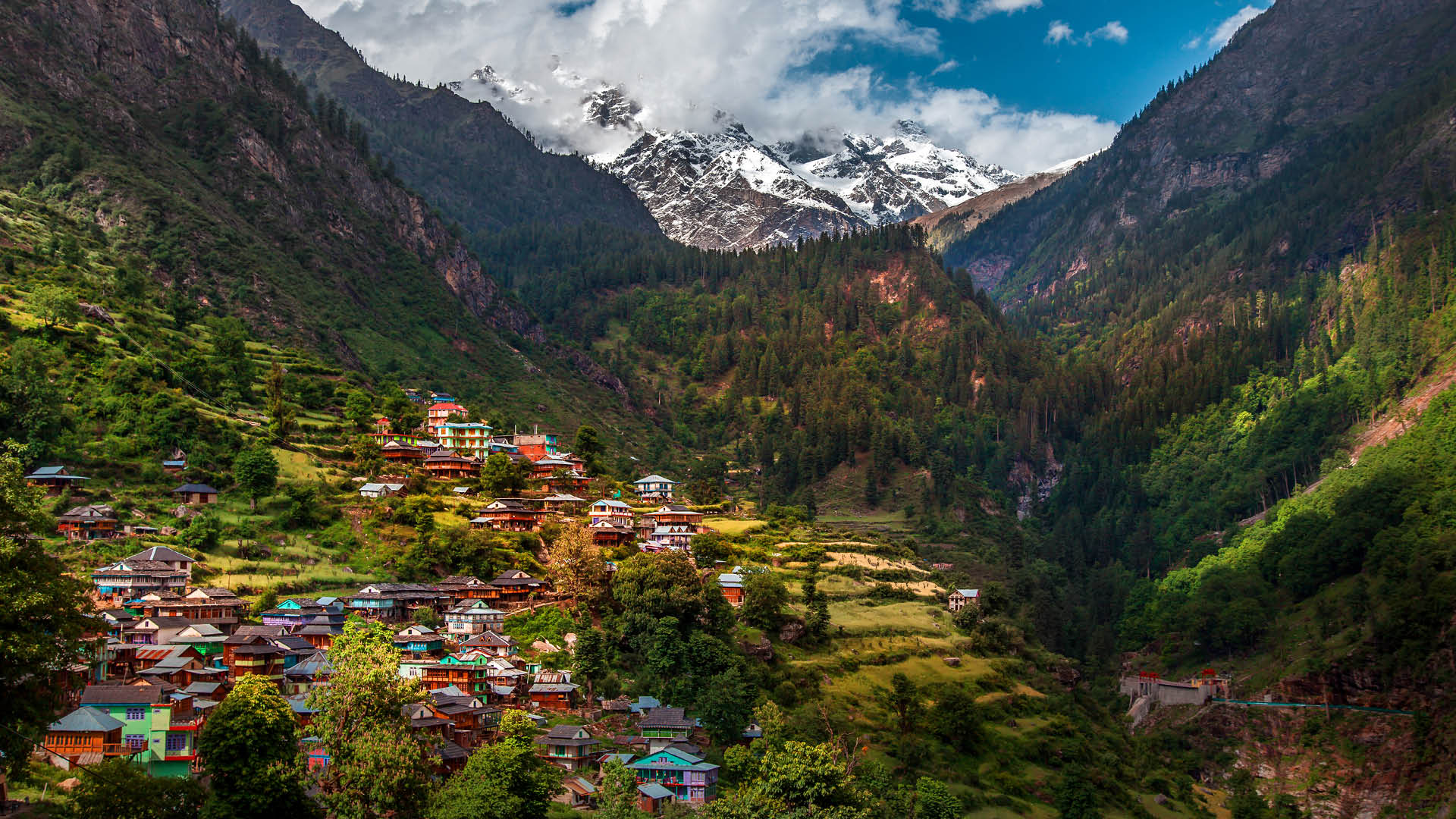
Arrive in Naggar in the morning and complete any permit formalities at the check post. The first day's walk is a gentle warm-up, climbing gradually through apple orchards and oak woodland before reaching Rumsu village. Rumsu is a small shepherd settlement where you'll set up camp. This easy opening day is intentional — your body begins adjusting to altitude without strain.
Day 2: Rumsu to Naya Tapru
- Distance: ~8 km
- Duration: ~5 hours
- Altitude gain: 2,000 m → 2,900 m (+900 m)
- Trail character: Steepening forest trail opening into rhododendron glades and high meadows
This is the most scenically varied day. The trail climbs steadily through increasingly sparse forest before bursting into the open at the Naya Tapru meadow — a broad, grassy plateau with the first unobstructed views of the surrounding ridges. Camp here overnight. Note that no permanent tea shops or dhabas exist beyond Rumsu, so carry all food for Days 2 and 3.
Day 3: Naya Tapru to Chanderkhani Pass and Return
- Distance: ~10 km (5 km each way)
- Duration: ~6–7 hours
- Altitude gain: 2,900 m → 3,660 m (+760 m)
- Trail character: Open alpine terrain, possible snow patches (May–June), rocky ridge approach
Start before 7 AM. The ascent to the pass is the steepest section of the entire trek, gaining nearly 760 m over 5 km. The trail crosses boulder fields and, in early season, significant snow patches before reaching the Chanderkhani Pass ridgeline. At the top, the panorama of Deo Tibba, Indrasan, and the Pir Panjal unfolds. Spend 30–60 minutes at the pass, then descend back to Naya Tapru (or continue down to Rumsu if energy allows).
Day 4: Return to Naggar / Manali
- Distance: ~14 km (Naya Tapru to Naggar)
- Duration: ~5–6 hours
- Altitude loss: 2,900 m → 1,800 m
A long but satisfying descent back through the forest to Naggar. From Naggar, take a shared taxi or bus back to Manali. If you stayed at Rumsu on Day 3 evening, Day 4 is a shorter ~6 km walk.
Campsite Details Along the Route
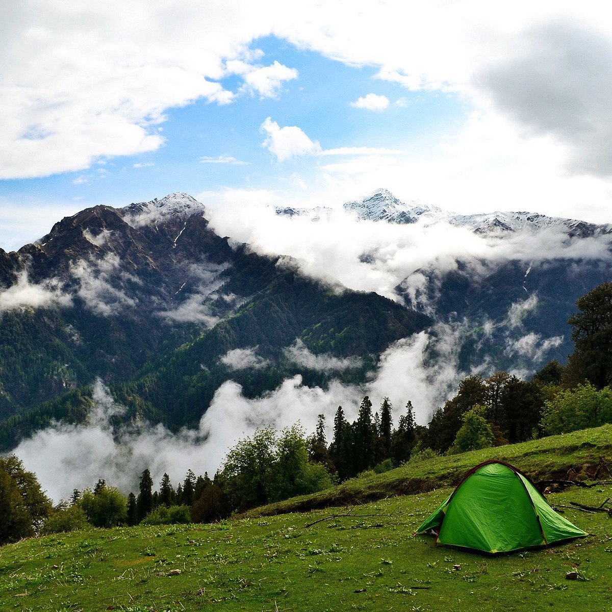
- Rumsu village campsite: Basic facilities including a flat camping ground near the village. Water is available from a natural spring — purify before drinking. Some villagers may offer basic food or chai; do not rely on this.
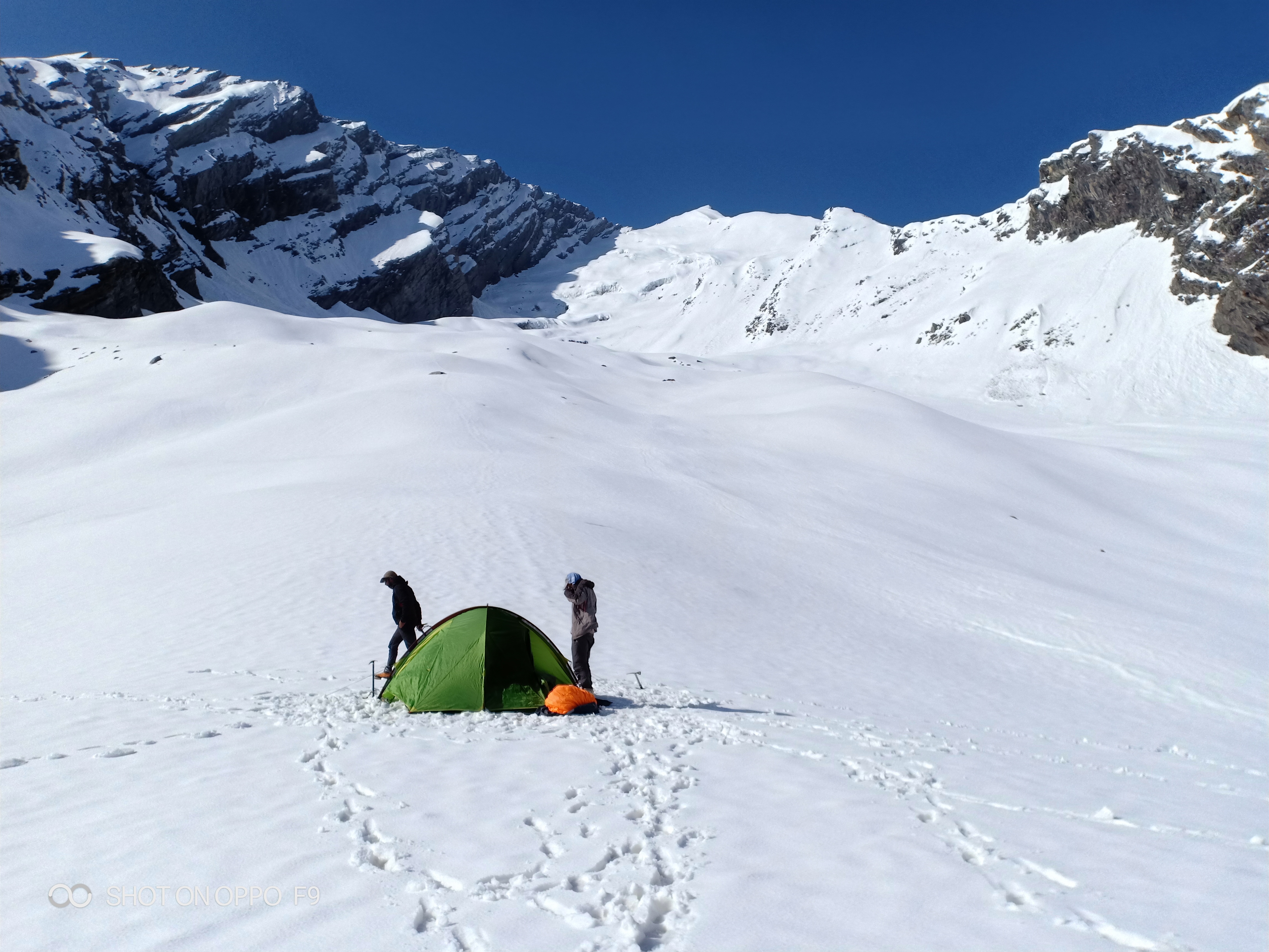
- Naya Tapru meadow campsite: Open alpine meadow with stunning ridge views. No shelter, no permanent facilities. Water from a nearby stream (must be purified). Can be exposed to wind — peg your tent securely.
- At the pass: No camping is recommended at the pass itself due to wind exposure and lack of flat ground. It is a turnaround point only.
- Important: Beyond Rumsu, carry all your own food and fuel for cooking. There are no permanent tea shops or dhabas on the upper trail.
When to go
The 2026 trekking season follows the same broad seasonal pattern as previous years, though always check current conditions locally before departure.
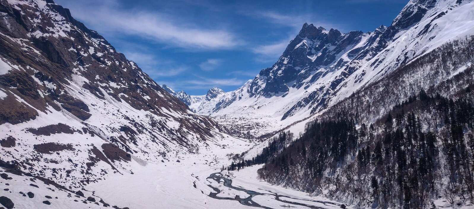
May – June (Recommended): Snow patches remain on the upper trail, creating dramatic landscapes. Skies are generally clear before the monsoon arrives. Temperatures are pleasant. This is arguably the most visually spectacular window for the Chanderkhani Pass trek. Microspikes are advisable for the final ascent in May.
July – August (Avoid if possible): The southwest monsoon brings significant rainfall to the Kullu Valley. Leeches appear in the forested lower sections. Trail visibility can be poor. The pass area may be cloud-covered for days at a time. Landslides can affect the road to Naggar. Experienced trekkers can manage, but beginners should avoid this window.
September – October (Recommended): Post-monsoon clarity is exceptional. The air is crisp, the sky is a deep blue, and the views of Deo Tibba and the Pir Panjal are at their sharpest. Autumn colours add beauty to the forest sections. September–October is the best season for photography. Nights become cold by October — pack accordingly.
November – April (Closed): Heavy snowfall makes the pass impassable. The route is not recommended, and local guides will not lead groups beyond Rumsu in these months.
Our recommendation: Plan for late May–mid-June or mid-September–mid-October for the best combination of clear views, stable weather, and manageable trail conditions.
Chanderkhani Pass Trek Weather by Month
| Month | Daytime Temp at Pass | Night Temp at Camp | Conditions |
|---|---|---|---|
| May | 5–15°C | -2 to 3°C | Snow on upper trail, clear skies |
| June | 8–18°C | 2–8°C | Pre-monsoon clarity, lush lower trail |
| July | 10–16°C | 5–10°C | Monsoon rain, reduced visibility |
| August | 10–16°C | 5–10°C | Heavy rain, leeches in forest |
| September | 5–14°C | 0–5°C | Post-monsoon clarity, excellent views |
| October | 0–10°C | -5 to 0°C | Cold nights, crisp clear days |
⚠️Temperature ranges are indicative estimates based on regional climate patterns. Actual conditions vary year to year. Check a mountain weather service (e.g., mountain-forecast.com) for the specific dates of your 2026 trek.
Is this trek right for you?
Overall rating: Easy-to-Moderate
The Chanderkhani Pass trek is well within reach of first-time trekkers who have put in some preparation. Here is what to expect:
- No technical climbing — No ropes, harnesses, or rock-climbing skills required at any point on the standard route.
- Steepest section: The Day 3 ascent from Naya Tapru to the pass is the most demanding stretch, but it is a matter of sustained effort rather than technical difficulty.
- Altitude: At 3,660 m, the pass is high enough to cause mild altitude sickness in unprepared trekkers. The gain is manageable if you follow a gradual itinerary.
- Fitness preparation (4 weeks before trek): 30 minutes of daily cardio (running, cycling, swimming), stair-climbing sessions 3–4 times per week, and loaded-pack walks on weekends.
- Acclimatisation: Spend at least one full day in Manali (2,050 m) before starting the trek. Do not ascend directly from a low-altitude city to the trailhead on the same day.
- Medical caution: Those with cardiac or respiratory conditions should obtain medical clearance before attempting this or any high-altitude trek. Read our altitude sickness prevention guide before travelling.
What permits you need
The good news for trekkers: the Chanderkhani Pass trek does not require an Inner Line Permit (ILP).
- Forest Department check post (Naggar): A local forest check post at or near Naggar may require you to register your group and pay a nominal entry fee. Carry a government-issued photo ID (Aadhaar card or Passport) for each group member. Permit copies should be kept accessible throughout the trek.
- Malana village entry fee: If your route exits via Malana village, a village entry fee of approximately ₹500–1,000 per person is collected at the village boundary. This is a community-managed fee, not a government permit. Exact 2026 rates should be confirmed locally.
- No online portal: As of our last update, there is no online permit portal for this trek. All documentation is handled at the Naggar check post on the day of entry.
- Recommended action: Contact the Kullu Forest Division (Kullu, Himachal Pradesh) before your 2026 trek to confirm current requirements, as permit rules can change between seasons.
⚠️ Permit requirements and fees for the 2026 season have not been independently verified. Treat the Malana entry fee range as approximate. Confirm with the Kullu Forest Division or a registered local guide.
What this trek will cost you
DIY Trek (Per Person, 4 Days)
| Expense | Estimated Cost (2026) |
|---|---|
| Manali–Naggar shared taxi (one way) | ₹100–200 per seat |
| Private cab Manali–Naggar (one way) | ₹500–800 |
| Camping gear rental (per day) | ₹300–600/day |
| Food (self-cooked/carried) | ₹500–800/day |
| Guide or porter | ₹1,000–1,500/day |
| Permit/entry fees | ₹200–1,000 (variable) |
| DIY Total (4 days) | ₹5,000–9,000 per person |
Organised Package (Per Person, 4 Days)
| Package type | Estimated Cost (2026) |
|---|---|
| Basic package (guide, tents, meals) | ₹8,000–12,000 |
| Premium package (all-inclusive) | ₹12,000–15,000 |
Organised packages typically include guide fees, camping equipment, all meals from Day 1 dinner to Day 4 lunch, and a safety briefing. TrekYatra partner packages for the Chanderkhani Pass trek are available for the 2026 season — check our best treks near Manali page for current listings.
⚠️ All cost figures are estimates for 2026 and should be verified with local operators and taxi stands before travel, as prices fluctuate with fuel costs and seasonal demand.
What to pack
For a comprehensive gear guide, see our Himalayan trek packing list. Below is the essential checklist for Chanderkhani Pass:
Clothing
- Moisture-wicking base layer (top and bottom)
- Mid-layer fleece or down jacket
- Waterproof, windproof outer shell (rain jacket)
- Thermal gloves and warm hat/beanie
- Trekking trousers (avoid jeans)
- Sun hat or cap
- Warm socks × 3 pairs
Footwear
- Ankle-support waterproof trekking boots (broken in before the trek)
- Camp sandals or lightweight shoes
- Gaiters (especially for May snow patches)
- Microspikes (recommended for May–early June)
Gear
- 40–50L backpack with rain cover
- Sleeping bag rated to -5°C or lower
- Sleeping mat or insulated pad
- Trekking poles × 2
- Headlamp with spare batteries
- Water bottles × 2 (at least 2 litres capacity total)
- Water purification tablets or filter
- Sunglasses (UV-rated)
- Sunscreen SPF 50+
- Lighter/matches
Safety
- Basic first-aid kit (bandages, antiseptic, blister pads)
- ORS sachets
- Diamox (acetazolamide) — only if prescribed by a doctor
- Personal medications
- Emergency whistle
Documents
- Government-issued photo ID (Aadhaar/Passport)
- Permit copies
- Emergency contact numbers (printed)
- Travel insurance documents
Food (for days beyond Rumsu)
- Energy bars and protein bars
- Dry fruits and nuts
- Instant noodles or freeze-dried meals
- Electrolyte powder/sachets
- Dark chocolate
Recommended gear for this trek
Staying safe on the mountain
Altitude and AMS
Spend at least one day acclimatising in Manali (2,050 m) before beginning the trek. Learn to recognise Acute Mountain Sickness (AMS) symptoms: persistent headache, nausea, dizziness, loss of appetite, and unusual fatigue. If symptoms worsen, descend immediately — do not sleep at a higher altitude if you feel unwell. Discuss Diamox with your doctor before travel. See our altitude sickness prevention guide.
Weather and Summit Timing
Begin the Day 3 pass push before 7 AM. Mountain weather in the Kullu region typically deteriorates in the afternoon, with clouds and occasional thunderstorms building after midday. Aim to be back at Naya Tapru by 1 PM.
Water Safety
Do not drink directly from streams, however clear they appear. Use water purification tablets or a filter for all stream water. ORS sachets help replace electrolytes lost during long ascent days.
Solo Trekking
Solo trekking on this route is not recommended. Go with at least one partner, or hire a registered local guide. Trails can be snow-covered and difficult to follow in May–June.
Snow on Trail
In May and early June, the upper section above 3,000 m can carry significant snow. Microspikes and trekking poles are strongly advised for this period.
Emergency Contacts
- Kullu District Emergency: 01902-222266
- Himachal Pradesh Tourism Helpline: 1800-180-8080
- Mountain Rescue (Manali): Contact the local police station at +91-1902-252340 (verify current number before travel)
- Always share your itinerary with someone not on the trek — a family member or your accommodation host in Manali.
Similar treks to explore
Kugti Pass Trek: Guide to Himachal's Hidden Crossing
The Kugti Pass trek is a difficult high-altitude crossing in Chamba, Himachal Pradesh, reaching ~4,920 m (16,142 ft) and connecting Chamba to Lahaul.
Friendship Peak Base Trek: Complete 2026 Guide
The Friendship Peak Base Trek is a 5–6 day moderate-to-difficult trek in Himachal Pradesh, starting at Dhundi (2480m) near Manali and reaching base camp at 4800–5000m beneath the 5289m summit.
Tosh Valley Trek: Guide to Parvati Valley's Hidden Gem
The Tosh Valley trek is a 3–4 km hike from Barshaini to Tosh Village (2,400 m) in Himachal Pradesh's Parvati Valley, rated easy to moderate and best done April–June.
Common questions answered
Yes. The trek is rated Easy-to-Moderate and requires no technical climbing skills. The trail is clearly defined, the altitude gain is gradual over 4 days, and the highest point of 3,660 m is manageable for most healthy individuals. The key prerequisites are basic cardiovascular fitness (built over 4 weeks of training) and one acclimatisation day in Manali before you start. Beginners who skip acclimatisation are the most common cause of trek abandonment on this route.