Why Kashmir Great Lakes Trek is on every trekker's list
The Kashmir Great Lakes Trek is an 8-day, 72 km moderate-difficult route from Sonamarg to Naranag, crossing 7 alpine lakes and 4 high passes up to 4,191 m, open July–mid-September.
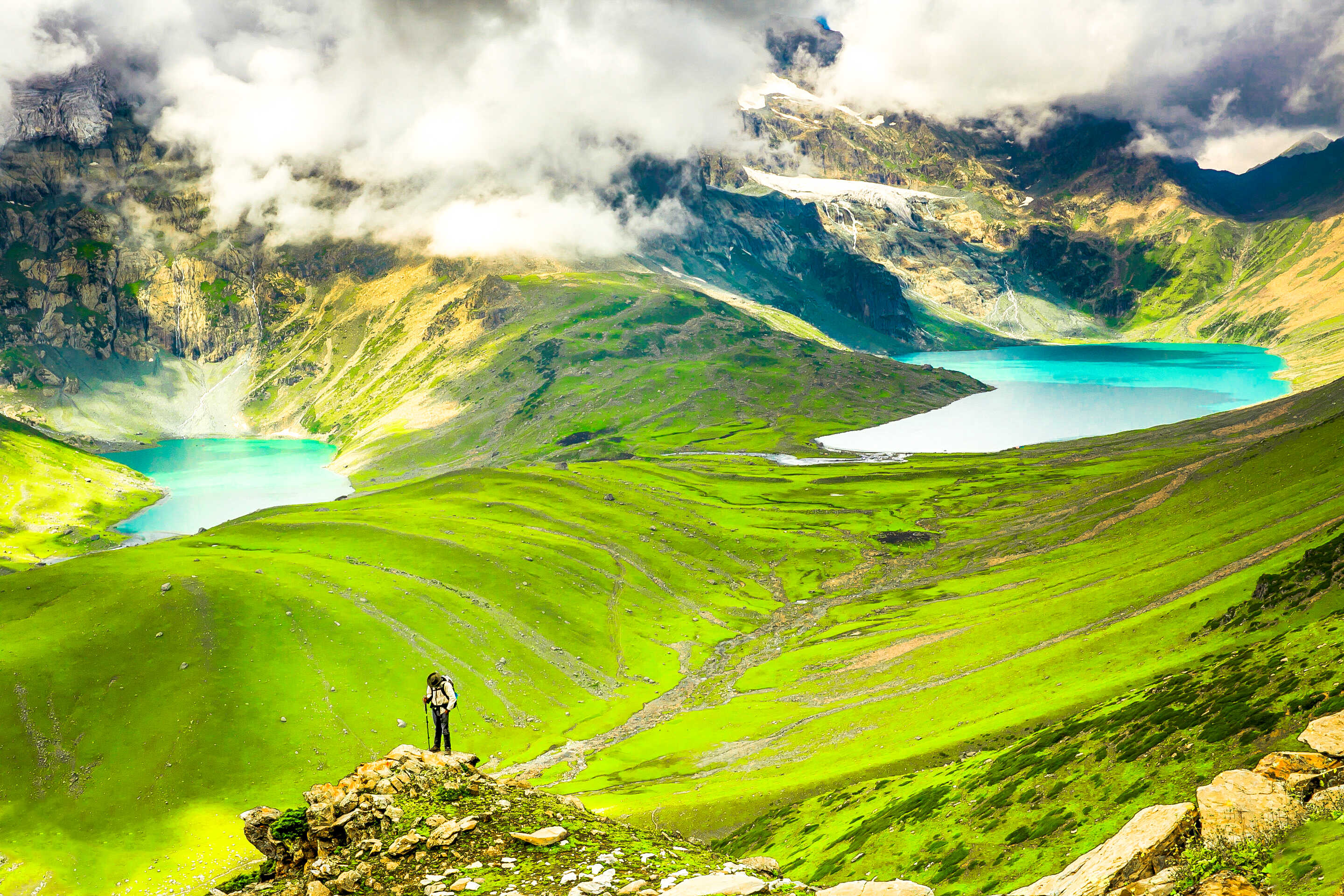
Few treks in India stop you mid-stride just to stare. The Kashmir Great Lakes Trek does it repeatedly — at the jade-green Vishansar, the twin reflections of Krishansar, the brooding Gadsar tucked below a 4,191 m pass, and the vast Gangabal that mirrors Harmukh Peak like a mirror. Spread across approximately 72 km of trail in the upper reaches of the Kashmir Valley, this route stitches together seven alpine lakes, four mountain passes, and some of the most flower-laden meadows on the Indian subcontinent.
Elevation ranges from roughly 2,800 m at Sonamarg to 4,191 m at Gadsar Pass. The trek is rated Moderate-Difficult, takes 8 days including travel days, and is accessible during a narrow seasonal window — July through mid-September. Whether you are a seasoned Himalayan trekker or someone stepping up from your first 4,000 m summit, this guide has every detail you need for the 2026 season.
India has dozens of multi-day treks, but the Kashmir Great Lakes route occupies a category of its own. Here is why:
Seven lakes, each completely different. Vishansar and Krishansar sit side by side in the same glacial bowl, yet have distinct colours depending on the light and season. Gadsar is remote and austere, rimmed by talus slopes. The Satsar cluster — a chain of seven small lakes strung across an open valley — feels more like a Scottish highland than the Himalayas. And Gangabal, the largest lake on the route, paired with Nundkol nearby, offers a campsite so dramatic that trekkers routinely spend an unplanned extra day there.
Meadow landscapes that rival alpine Europe. The route passes through vast margs (high-altitude meadows) carpeted with Himalayan wildflowers in July and August — blue gentians, yellow cinquefoil, purple iris, and white anemones grow in such density that the trail sometimes disappears into them.
Relative trail solitude. Compared to Himachal Pradesh's well-trampled routes like Hampta Pass or Pin Parbati, the Kashmir Great Lakes remains less crowded — partly because the region requires more logistical planning, and partly because Kashmir's tourism recovery is still ongoing. In September especially, you can walk entire stretches without seeing another tent.
Proximity to extraordinary biodiversity. The trail passes near the buffer zones of the Great Himalayas National Park (a UNESCO World Heritage Site), and the upper valleys support populations of snow leopard, Himalayan brown bear, marmot, and the rare Kashmir stag (hangul). Bird diversity along the route is exceptional for high-altitude terrain.
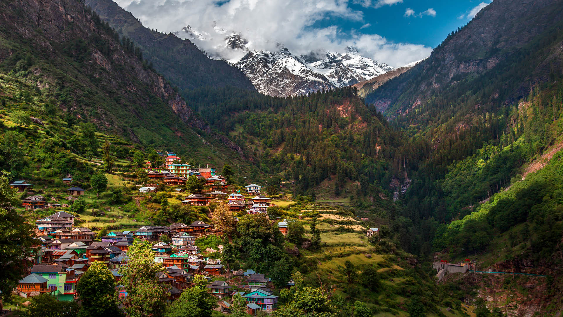
The emotional weight of the landscape. Kashmir carries a complicated modern history, and trekking through its high valleys — stopping in shepherd settlements, drinking kahwa with Gujjar herders, watching the evening light go gold on Harmukh — is as culturally resonant as it is physically demanding.
At a glance
The route at a glance
The standard route runs from Sonamarg (northwest) to Naranag (southeast), a point-to-point traverse of the upper Kashmir range.
Starting point: Sonamarg (approx. 2,800 m) — a well-connected hill town 87 km from Srinagar on the Srinagar–Leh highway. See our Sonamarg Trekking Guide for base-camp logistics.
Ending point: Naranag (approx. 2,100 m) — a small village in the Wangath Valley, roughly 60 km from Srinagar, known for its ancient 8th-century Shiva temple ruins.
Key waypoints and passes:
- Sonamarg → Nichnai Camp (via Nichnai Pass, ~3,400 m) — The route climbs steadily through pine forest and then open meadow before crossing the first pass.
- Nichnai → Vishansar Lake (~3,710 m) — The descent from Nichnai leads into the Krishansar–Vishansar basin. The sight of these twin lakes from the ridge above is the trek's first major payoff.
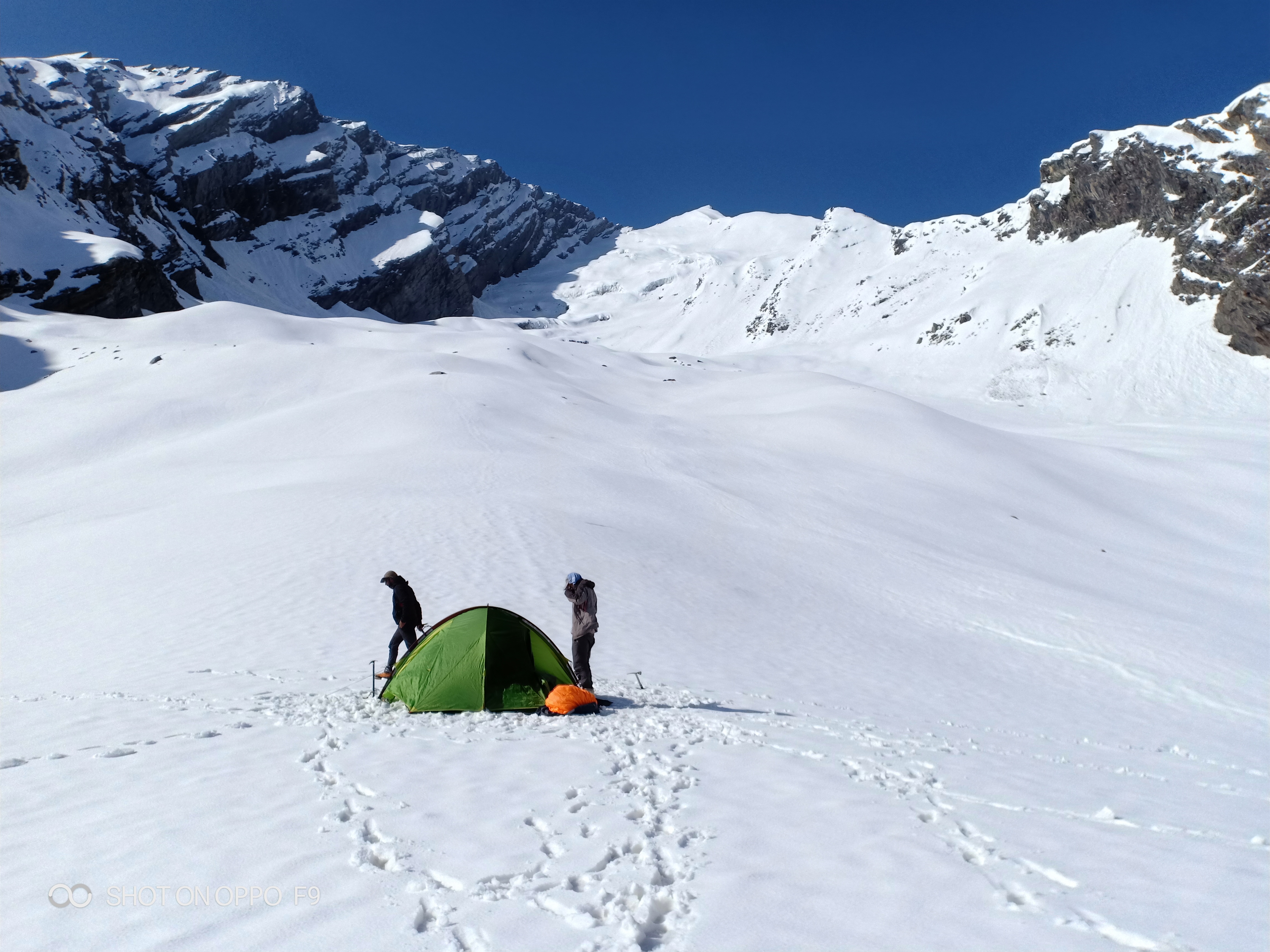
- Vishansar → Gadsar (via Gadsar Pass, ~4,191 m) — This is the highest and most demanding day. Gadsar Pass involves significant elevation gain on rocky terrain. Gadsar Lake sits directly below.
- Gadsar → Satsar Camp — A long valley traverse through the Satsar chain of lakes. The terrain is relatively flat here, offering recovery walking.
- Satsar → Gangabal Twin Lakes (via Zaj Pass or Trunkhal Pass route variants, ~3,900 m) — The final high crossing before the grand Gangabal–Nundkol campsite beneath Harmukh.
- Gangabal → Naranag — A long descent through the Wangath Valley on a well-defined trail, ending at the roadhead.
Total trail distance: Approximately 72 km
Elevation profile summary: Start 2,800 m → Rise to 3,400 m (Nichnai) → Dip to 3,710 m (Vishansar) → Peak at 4,191 m (Gadsar Pass) → Descend through 3,600–3,900 m to Gangabal → Drop to 2,100 m (Naranag).
For a comparable but shorter Kashmir lakes experience, see our guide to the Tarsar Marsar Trek.
What each day actually looks like
The itinerary below is the most commonly used 8-day structure (2 travel days + 6 trekking days).
Day 1 — Srinagar to Sonamarg (Drive)
- Drive: ~87 km, approximately 2.5–3 hours
- Altitude: Arrive at ~2,800 m
- Task: Permit collection, gear check, briefing with guide
- Stay: Sonamarg guesthouse or tent camp
- Difficulty: Easy (travel day)
Day 2 — Sonamarg to Nichnai Camp
- Distance: ~12 km
- Altitude: 2,800 m → ~3,400 m (gain ~600 m)
- Duration: 5–6 hours
- Highlights: Sindh River crossing, alpine meadows, Nichnai Pass views
- Difficulty: Moderate
- Note: First day at altitude — pace yourself; do not push speed.
Day 3 — Nichnai to Vishansar Lake
- Distance: ~13 km
- Altitude: 3,400 m → ~3,710 m (with a ridge crossing near 3,800 m)
- Duration: 6–7 hours
- Highlights: First views of Krishansar Lake, descent to Vishansar basin
- Difficulty: Moderate
Day 4 — Vishansar to Gadsar (via Gadsar Pass)
- Distance: ~15 km
- Altitude: 3,710 m → 4,191 m (Gadsar Pass) → ~3,600 m (Gadsar Lake camp)
- Duration: 7–8 hours
- Highlights: Gadsar Pass at 4,191 m — the highest point of the trek; Gadsar Lake below
- Difficulty: Hard — highest day, significant elevation gain, rocky terrain
- AMS risk: High — monitor for headache, nausea. Carry Diamox as advised by your doctor.
Day 5 — Gadsar to Satsar Camp
- Distance: ~14 km
- Altitude: ~3,600 m → ~3,700 m (relatively flat)
- Duration: 5–6 hours
- Highlights: Satsar chain of lakes, wide open valley, Gujjar shepherd camps
- Difficulty: Moderate — a relative recovery day after Gadsar Pass
Day 6 — Satsar to Gangabal Twin Lakes (via Zaj Pass)
- Distance: ~11 km
- Altitude: ~3,700 m → ~3,900 m (Zaj Pass area) → ~3,570 m (Gangabal)
- Duration: 6–7 hours
- Highlights: Gangabal Lake and Nundkol Lake, Harmukh Peak reflection
- Difficulty: Moderate-Hard
- Note: Route via Trunkhal Pass is an alternative variant — confirm with your guide based on current snow conditions.
Day 7 — Gangabal to Naranag
- Distance: ~12 km
- Altitude: ~3,570 m → ~2,100 m (descent ~1,470 m)
- Duration: 5–6 hours
- Highlights: Ancient Naranag temple ruins at trail end, forest trail through Wangath Valley
- Difficulty: Moderate — long descent, knee-intensive
Day 8 — Naranag to Srinagar (Drive)
- Drive: ~60 km, approximately 2 hours
- Task: Return, gear return if rented, debrief
- Difficulty: Easy (travel day)
When to go
July to mid-September is the trekking window for the Kashmir Great Lakes. Here is what each period looks like:
July–August (Peak Season)
All passes are open, wildflowers are at their peak, and the trail is most accessible. Expect some afternoon cloud build-up and occasional thunderstorms, especially in August. Crowds are at their highest, but still modest compared to Himachal routes. Nights are cold (5°C–0°C at camp), days are pleasant (15°C–20°C at lower altitudes). Best for first-timers on this route.
September (Shoulder Season)
Skies are dramatically clearer — ideal for photography. Temperatures drop sharply at night (sub-zero above 3,500 m). Fewer trekkers on trail. Wildflowers have peaked but the golden meadow grass makes for beautiful landscapes. Some higher slopes may see early snow in late September. Best for experienced trekkers who prioritise views.
June (Early Season — Experienced Only)
Gadsar Pass and other high crossings may still carry 3–5 m of snow. Route-finding is difficult. Only recommended for trekkers with prior snow-trekking experience and an experienced guide who knows the route under snow. Not suitable for casual trekkers.
October Onwards — Avoid
Heavy snowfall typically closes all passes by mid-to-late October. Trail is officially inaccessible. Risk of being trapped by sudden snowstorm is real.
Monsoon Note
The Kashmir Valley lies in the rain shadow of the Pir Panjal range. Unlike Himachal Pradesh and Uttarakhand, it does not receive the full force of the southwest monsoon. Trail conditions during July–August are generally safe, though localised afternoon rain is common. Always start walking by 6–7 AM to clear high passes before afternoon weather builds.
Is this trek right for you?
Overall rating: Moderate-Difficult
Do not let Instagram photos mislead you — this is a demanding trek.
- Daily walking: 5–8 hours, 11–15 km per day
- Cumulative elevation gain: Approximately 5,000 m over the full route
- Highest point: 4,191 m (Gadsar Pass) — AMS risk is real above 3,500 m
- Terrain: Mix of forest trail, rocky moraine, snowfield, and grassy meadow
Who should attempt this trek:
- Trekkers with at least one prior high-altitude trek above 3,500 m (e.g., Kedarkantha, Hampta Pass, Buran Ghati)
- Those comfortable walking 6+ hours with a 10–12 kg pack
- People in good cardiovascular health
Who should NOT attempt without medical clearance:
- First-time trekkers with no high-altitude experience
- Anyone with cardiac or respiratory conditions
- Trekkers who have not been active for 3+ months
Recommended Training (6–8 weeks before trek):
- 4–5 days per week: Cardio (running, stair climbing, cycling) — build to 60 minutes continuous
- 3 days per week: Leg strength (squats, lunges, step-ups with weight)
- Weekend: Practice hikes with loaded pack (8–10 kg) on inclined terrain
For a structured plan, see our Himalayan Trek Fitness Training guide. Also read our Altitude Sickness Prevention Guide before departure.
What permits you need
Indian Nationals
- Inner Line Permit (ILP): Not required for Indian nationals trekking this zone as of 2026.
- J&K Forest Department Camping Permit: Mandatory. This permit is required for camping within the forest and wildlife buffer zones along the route.
- Cost: Approximately ₹100–₹200 per person per day.
- Where to obtain: Through a registered trekking operator (most convenient) or directly from the Forest Office in Sonamarg or Srinagar.
- Documents required: Aadhaar card (carry physical copy), passport-size photographs.
Foreign Nationals
- Restricted Area Permit (RAP): Required in addition to the camping permit. Foreign nationals must obtain this through the Foreigners Registration Office (FRO) in Srinagar or through a registered tour operator with the requisite government approval.
- Processing time for RAP can be 1–3 working days — plan accordingly and do not arrive in Srinagar on the eve of your trek expecting same-day processing.
Important Note on Permit Rules
Permit regulations in Jammu & Kashmir are subject to change with limited advance notice. Always verify current requirements through the official J&K Tourism website or by calling the Forest Department office in Sonamarg before your trek. Do not rely solely on operator briefings from previous seasons.
What this trek will cost you
DIY Trekker Budget (Per Person)
| Item | Estimated Cost |
|---|---|
| Shared taxi Srinagar–Sonamarg | ₹800–₹1,500 |
| Shared taxi Naranag–Srinagar | ₹700–₹1,200 |
| Forest Department camping permit (7 days) | ₹700–₹1,400 |
| Local guide (7 days × ₹1,500/day) | ₹10,500 |
| Porter (optional, 7 days × ₹1,200/day) | ₹8,400 |
| Camping gear rental (sleeping bag, tent, poles — 7 days × ₹500) | ₹3,500 |
| Food/rations (7 days × ₹500) | ₹3,500 |
| Sonamarg accommodation (1 night) | ₹600–₹1,200 |
| Miscellaneous (tips, medication, contingency) | ₹1,000–₹2,000 |
| Total DIY (without porter) | ~₹20,000–₹25,000 |
| Total DIY (with porter) | ~₹28,000–₹34,000 |
Note: DIY costs assume you own some personal gear (clothing, boots, daypack). If renting all gear, add ₹3,000–₹5,000.
Organised Package (Per Person)
| Package Type | Price Range |
|---|---|
| Budget/Group package (10+ people) | ₹18,000–₹22,000 |
| Mid-range package (6–10 people) | ₹22,000–₹28,000 |
| Premium/private package | ₹30,000–₹45,000+ |
Typically included: Shared tent, sleeping bag, all meals on trail, guide, permits, camp staff, mule support, basic first aid kit.
Typically excluded: Srinagar hotel before/after trek, personal trekking gear, travel insurance, porter tips, personal snacks.
Our advice: For a first attempt at this trek, an organised package from a reputable operator is worth the cost premium — local guides know current snow and route conditions, and evacuation logistics are pre-arranged.
What to pack
Clothing (Layering System)
- Moisture-wicking base layer (top and bottom) × 2
- Mid-layer fleece or down jacket
- Waterproof, windproof outer shell jacket (essential — do not substitute with a light raincoat)
- Thermal leggings for camp and cold nights
- Trekking pants × 2 (one convertible)
- Warm hat and sun hat
- Balaclava or neck gaiter
- Trekking gloves + spare light gloves
- 4–5 pairs merino wool or synthetic trekking socks
Footwear
- Waterproof ankle-support trekking boots (broken-in before trek) — see our Best Trekking Boots India guide
- Gaiters (essential on snow sections in June–July)
- Lightweight camp sandals or flip-flops
Gear
- Sleeping bag rated -10°C or lower — see our Sleeping Bag Buying Guide
- Trekking poles × 2 (collapsible, with snow baskets)
- 40–50 litre trekking backpack with rain cover
- Headlamp + spare batteries
- Trekking tent (if DIY; provided by operators)
- Sunglasses (UV400 — snow glare at passes is intense)
- Sunscreen SPF 50+ and lip balm with SPF
- Water bottles (1 L × 2) + water purification tablets or SteriPen
- Trekking map or offline route on phone (GPS app like Wikiloc or Gaia)
Nutrition
- ORS sachets (10–15 minimum) — critical for hydration management
- Energy bars and trail mix (carry 2 days' emergency supply beyond planned meals)
- Dry fruits, nuts, dark chocolate
- Electrolyte powder
Documents
- Aadhaar card (physical copy × 2)
- Trekking permits (carry printed copy)
- Emergency contacts list (printed, not just on phone)
- Trek insurance policy document
- Cash in small denominations (no ATMs beyond Sonamarg)
First Aid (Personal Kit)
- Diamox (Acetazolamide) — consult your doctor before carrying; standard prophylactic dose is 125–250 mg twice daily starting 24 hours before ascent
- Dolo 650 (paracetamol) for fever and headache
- Ibuprofen for muscle pain and mild AMS headache
- Blister kit (moleskin, needle, antiseptic)
- Crepe bandage
- Antiseptic cream and plasters
- Personal prescription medications
Recommended gear for this trek
Staying safe on the mountain
How Do You Prevent Altitude Sickness on This Trek?
AMS can affect anyone above 2,500 m, regardless of fitness level. On this trek, the critical altitude threshold is Gadsar Pass at 4,191 m.
Recognise the symptoms: Persistent headache, nausea, vomiting, dizziness, fatigue disproportionate to effort, loss of appetite, disturbed sleep.
Protocol:
1. At first AMS symptoms, do not ascend further.
2. Rest at current altitude for 6–12 hours and hydrate.
3. If symptoms worsen, descend immediately — descent of even 300–500 m dramatically relieves mild-to-moderate AMS.
4. Diamox can help acclimatisation — discuss dosage and contraindications with your doctor before the trek, not during it.
5. In severe cases (confusion, loss of coordination, breathlessness at rest), initiate emergency evacuation immediately.
See our detailed Altitude Sickness Prevention Guide.
Weather Awareness
- Afternoon thunderstorms are common in August. Start each day's walk by 6–7 AM and aim to cross all high passes before 12–1 PM.
- Weather on the Kashmir high range changes in under 30 minutes. Always carry your rain shell accessible, not buried in your pack.
- If lightning approaches a high pass, stop and descend to the nearest lower terrain — do not shelter under isolated rocks or trees.
Mobile Network and Communication
- Most of the route has no mobile network. BSNL offers partial signal at Sonamarg (start point) and Naranag (end point) and occasionally at intermediate high ridges — do not rely on it.
- Carry a satellite communicator (Garmin inReach or similar) if trekking semi-independently.
- Leave your full itinerary with a contact person in Srinagar.
Emergency Contacts
- J&K Police Emergency: 100
- Mountain Rescue Sonamarg: Contact the local police post at Sonamarg before trek departure (get the duty officer's number)
- Nearest hospital: SMHS Hospital Srinagar (+91-194-2452403)
Trek Insurance
Trek insurance covering high-altitude evacuation (helicopter rescue up to 5,000 m) is strongly recommended and required by most organised operators. Standard travel insurance is often insufficient — read the fine print for altitude coverage.
Is It Safe to Do the Kashmir Great Lakes Trek Solo?
Technically permitted for Indian nationals, but strongly discouraged. The route has extended stretches without mobile coverage, medical emergencies require mule or helicopter evacuation, and route-finding on snow sections demands local knowledge. At minimum, hire a registered local guide. For more, see our Best Treks in India overview, which includes safety frameworks for solo trekking.
Evacuation Points
- Mule evacuation (the most common emergency response) is possible from most campsites to Sonamarg or Naranag, but takes several hours.
- Helicopter landing zones exist near Gangabal Lake and Sonamarg — your guide should know current protocols.
Similar treks to explore
Friendship Peak Base Trek: Complete 2026 Guide
The Friendship Peak Base Trek is a 5–6 day moderate-to-difficult trek in Himachal Pradesh, starting at Dhundi (2480m) near Manali and reaching base camp at 4800–5000m beneath the 5289m summit.
Tosh Valley Trek: Guide to Parvati Valley's Hidden Gem
The Tosh Valley trek is a 3–4 km hike from Barshaini to Tosh Village (2,400 m) in Himachal Pradesh's Parvati Valley, rated easy to moderate and best done April–June.

Sar Pass Trek: Complete Guide 2026 (Route & Tips)
Sar Pass Trek is a 49 km moderate Himalayan trek in Himachal Pradesh, reaching 4,250 m, best done May–June over 5–6 days from Kasol to Barshaini.
Common questions answered
The trek covers approximately 72 km over 6 trekking days (8 days total including travel days to/from Srinagar). The route passes through 7 alpine lakes between Sonamarg and Naranag.