Why Kugti Pass Trek is on every trekker's list
Tucked deep inside the Chamba district of Himachal Pradesh, the Kugti Pass trek is the kind of journey most trekkers only dream about. Cresting at approximately 4,920 metres (16,142 ft), the pass stitches together the forested valleys of Chamba with the stark, wind-scoured landscapes of Lahaul-Spiti — all without the queues and Instagram crowds that now define many Himalayan classics. If you are searching for a genuine wilderness experience in the Indian Himalaya in the 2026 trekking season, this route deserves to be at the very top of your list.
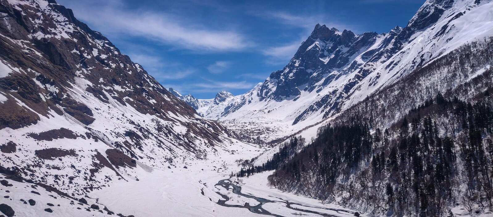
The trek traverses the protected bounds of the Kugti Wildlife Sanctuary, crosses glacial streams fed by the Pir Panjal snowfields, and passes through meadows where Gaddi shepherds have herded their flocks for centuries. Remoteness is both the challenge and the reward here — plan carefully, and you will carry memories that polished resort treks simply cannot offer.
In a landscape of hidden treks in Himachal Pradesh, Kugti Pass stands apart for reasons that go well beyond altitude. While routes like Hampta Pass or Triund see thousands of boots every season, the trail from Brahmaur to the Lahaul side via Kugti remains blessedly quiet. Here is why serious trekkers are increasingly adding it to their bucket list.
Raw, unmediated wilderness. The route enters the core zone of Kugti Wildlife Sanctuary almost immediately after Kugti village. The sanctuary is home to snow leopard, Himalayan brown bear, bharal (blue sheep), musk deer, and a rich array of high-altitude birds. You are a guest in a working ecosystem, not a managed experience.
A true cross-mountain journey. The pass connects Kugti village in Chamba to the Trilokinath and Miyar Valley region of Lahaul. Crossing from the lush, forested Chamba side to the rain-shadow, Tibetan-influenced Lahaul landscape in a single trek is a genuine geographic and cultural transition.
Panoramic scale. On clear summit days, the views from the pass sweep across the Pir Panjal Range to the south and the Zanskar Range to the north — a 360-degree canvas of some of the most dramatic mountains in Asia.
Cultural depth. The lower trail, particularly around Kugti village and the approach meadows, is traditional summer grazing territory for the Gaddi shepherds — one of Himachal's most distinctive pastoral communities. Sharing a campfire with a Gaddi herder who knows every boulder on this trail is worth more than any guided cultural tour.
For more inspiration, browse our curated list of hidden treks in Himachal Pradesh or explore our broader Himachal Pradesh trek index.
At a glance
The route at a glance
The Kugti Pass trek route follows a logical line from the road-head at Brahmaur (2,195 m), ascending steadily through mixed conifer and alpine forest to Kugti village, then pushing up through a series of high meadows before the final rocky climb to the Kugti Pass altitude of ~4,920 m. The descent on the Lahaul side drops toward Trilokinath or Udaipur, where road access resumes.
Total distance: approximately 55–65 km one-way (Brahmaur to Trilokinath side). A return trek roughly doubles this figure.
Elevation Profile (text table)
| Waypoint | Altitude | Cumulative Distance from Brahmaur |
|---|---|---|
| Brahmaur | 2,195 m | 0 km |
| Kugti Village | ~2,540 m | ~14 km |
| Nayaghar Meadows Camp | ~3,600 m | ~24 km |
| Alyas Meadows | ~4,100 m | ~32 km |
| Kugti Pass | ~4,920 m | ~40 km |
| Trilokinath side descent camp | ~3,800 m | ~48 km |
| Trilokinath / road access | ~2,760 m | ~60 km |
Note: All distances and altitudes are approximate. Verify with a current topographic map or local guide before departure.
Key landmarks on trail:
- Kugti village — the last permanent habitation before the high wilderness; basic provisions sometimes available but do not rely on it.
- Glacial stream crossings — multiple crossings above Kugti village, severity depending on season.
- Boulder and scree sections near the pass — the final 300–400 m of ascent to the pass involves loose scree and, in early season, snow patches.
- Alyas Meadows — a spectacular high-altitude bowl, critical acclimatisation stage.
Key Waypoints and Distances
- Brahmaur (2,195 m) — Road-head, permits, last ATM and resupply.
- Kugti Village (2,540 m) — ~14 km from Brahmaur; Forest Range checkpoint, last mobile signal.
- Nayaghar Camp (3,600 m) — ~10 km from Kugti village; open meadow camping, water from stream.
- Alyas Meadows (4,100 m) — ~8 km from Nayaghar; wide plateau, acclimatisation day camp.
- Kugti Pass (4,920 m) — ~8 km from Alyas; highest point, stunning panoramic views.
- Trilokinath descent camp (~3,800 m) — ~5–8 km below the pass on Lahaul side.
- Trilokinath / Udaipur (~2,760 m) — Road access, transport to Keylong or Manali.
What each day actually looks like
This Kugti Pass trek itinerary is designed as a one-way traverse from Brahmaur to the Lahaul side over 7–8 days. Very fit trekkers with a local guide can compress this to 6 days, but the acclimatisation day at Alyas should not be sacrificed.
Day 1 — Drive to Brahmaur
Altitude: 2,195 m | Drive: ~10–12 hrs from Delhi; ~8–9 hrs from Chandigarh via Chamba
Travel from Delhi or Chandigarh to Brahmaur by road via Pathankot and Chamba town. The Chamba–Brahmaur stretch (~65 km) winds through steep gorges and takes 2.5–3 hours. Arrive by evening, check into a guesthouse, collect your Kugti Wildlife Sanctuary permit from the Forest Range Office in Brahmaur, and confirm your guide/porter arrangements. Rest early.
Day 2 — Brahmaur to Kugti Village
Altitude: 2,195 m → 2,540 m | Distance: ~14 km | Duration: 5–6 hrs
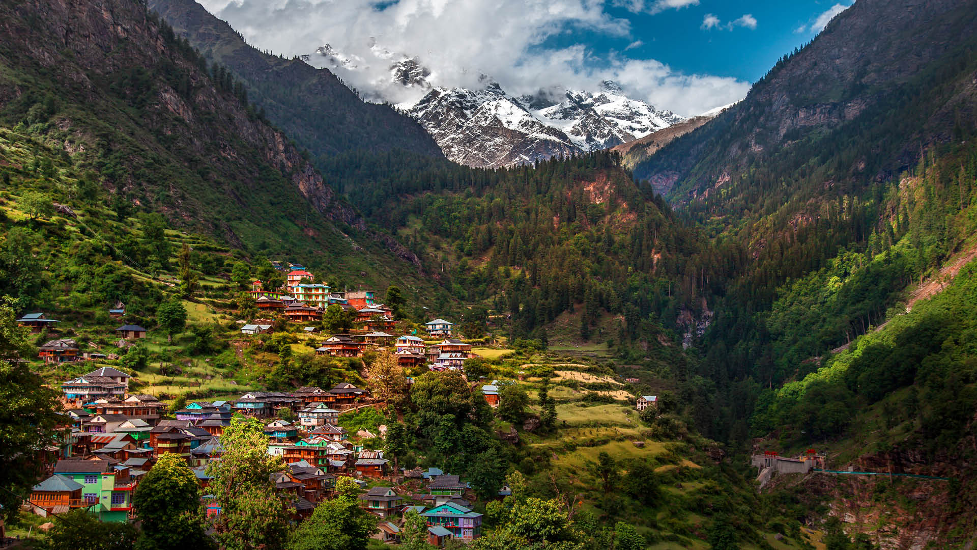
A long but mostly gradual day through forest and riverside trail following the Budhil River. The trail is well-defined in the lower sections. Pass small settlements before reaching Kugti village — a cluster of traditional stone houses. Camp at or near the village. This is your last reliable water supply point before the high valley.
Day 3 — Kugti Village to Nayaghar Meadows
Altitude: 2,540 m → 3,600 m | Distance: ~10 km | Duration: 5–6 hrs
The valley opens dramatically as you leave Kugti. The trail climbs through birch and juniper forest before emerging into open alpine meadows. Expect your first glacial stream crossings today — use trekking poles for stability. Camp at Nayaghar, a broad meadow with reliable stream water. The altitude gain (~1,060 m) is significant; walk slowly and stay hydrated.
Day 4 — Nayaghar to Alyas Meadows (Acclimatisation)
Altitude: 3,600 m → 4,100 m | Distance: ~8 km | Duration: 4–5 hrs
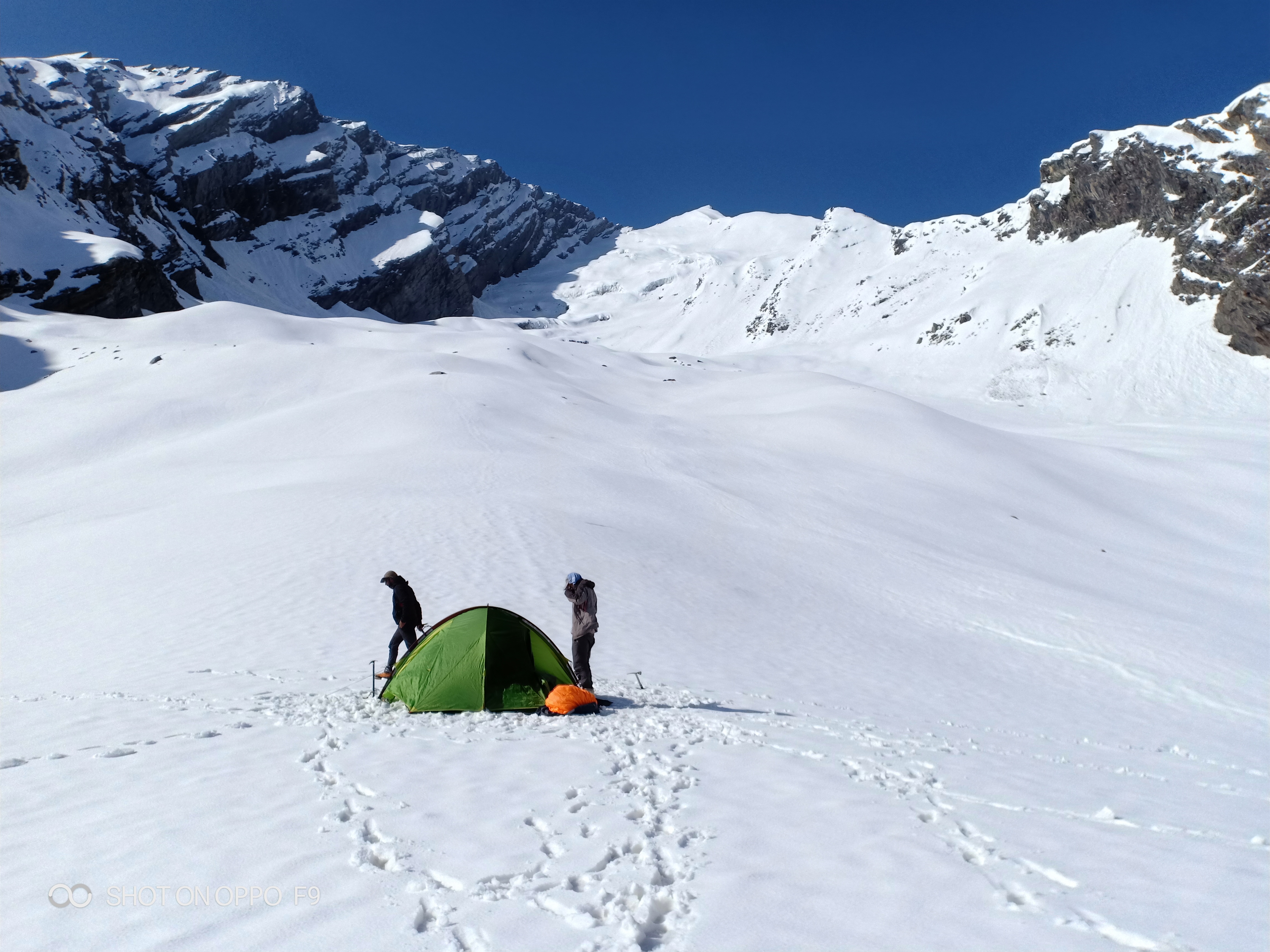
A shorter day by design. Arrive at Alyas Meadows by early afternoon. Spend the rest of the day acclimatising — see the acclimatisation tips section below. The meadow views are extraordinary: snow fields, distant peaks, and the vast silence of the sanctuary.
Day 5 — Alyas to Kugti Pass and Descent to Lahaul Side Camp (Summit Day)
Altitude: 4,100 m → 4,920 m → ~3,800 m | Distance: ~12–14 km | Duration: 8–10 hrs
The most demanding day. Start before 5:30 AM to reach the pass in morning calm and avoid afternoon weather. The ascent from Alyas to the pass involves scree, possibly snow, and a final steep push. Spend a few minutes at the top to absorb the views of the Pir Panjal and Zanskar ranges. Descend carefully — the Lahaul side can be equally loose underfoot. Camp at a suitable site on the Lahaul flank, approximately 3,800 m.
Day 6 — Descend to Trilokinath or Udaipur
Altitude: ~3,800 m → ~2,760 m | Distance: ~12–15 km | Duration: 5–7 hrs
Descend through increasingly dramatic Lahaul terrain to Trilokinath village, home to a revered multi-faith temple attracting both Hindu and Buddhist pilgrims. Alternatively, continue to Udaipur (Lahaul), the nearest large settlement with guesthouses and road transport. Mobile signal returns.
Day 7 — Exit and Onward Travel
From Trilokinath or Udaipur, take local transport to Keylong (district HQ of Lahaul-Spiti), then onward to Manali or return toward Chamba via Rohtang/Atal Tunnel. Buffer this day for any delays. This completes the one-way traverse.
Return variant: If you prefer a round-trip back to Brahmaur, add 3–4 days for the return crossing. This requires careful weather monitoring as conditions can deteriorate quickly.
Acclimatisation Day Tips
Day 4 at Alyas Meadows (4,100 m) is not a rest day — it is an insurance policy against altitude sickness. Here is how to use it well:
- Short exploratory walk: Ascend 200–300 m above camp in the afternoon, then return to sleep low. This classic "climb high, sleep low" principle accelerates adaptation.
- Hydration: Aim for 3–4 litres of water across the day. Avoid alcohol entirely.
- Watch for warning signs: Persistent headache unrelieved by paracetamol, nausea, loss of coordination, or breathlessness at rest are red flags. Do not ascend further if these appear — descend at least 300–500 m and reassess.
- Eat adequately: Altitude suppresses appetite but your body needs fuel. Force yourself to eat carbohydrate-rich foods.
- Sleep: Prioritise 7–8 hours. Sleep disturbance is normal at altitude; Diamox (prescribed dose, consult your doctor) can help with periodic breathing.
See our in-depth altitude sickness prevention guide for a comprehensive overview.
When to go
Choosing the right window is critical on this remote route. Kugti Pass trek weather is highly variable and the pass is snowbound for roughly seven months of the year.
Season Breakdown
Mid-June to July (Summer Opening)
This is the first viable window of the 2026 season. Snow is actively melting, meadows are exploding with wildflowers, and glacial streams are full — which means dramatic scenery but also more challenging river crossings. The pass itself may still hold snow patches in June, adding a mountaineering dimension. Expect cool nights (-5°C to -10°C at high camps).
August (Monsoon — Avoid if Possible)
The monsoon affects Chamba more than it does Lahaul. Lower trail sections can become slippery and leech-infested. Flash flood risk in the Budhil gorge is real. Afternoon thunderstorms are frequent. Experienced trekkers with local guide support can still complete the route, but we do not recommend it for most.
September to Early October (Post-Monsoon — Optimal)
This is arguably the best time to visit Kugti Pass. Skies are crystalline, meadows turn gold and amber, streams stabilise, and the mountain panorama from the pass is at its finest. Temperatures are manageable and precipitation is low. Book your guide well in advance for this window as demand from experienced trekkers peaks.
November to May (Closed)
The pass is buried under several metres of snow. Do not attempt it. Even the lower approaches can be dangerous due to avalanche risk in winter and early spring.
Best overall window: Mid-June to early October, with September as the premium choice for most trekkers.
Is this trek right for you?
Grade: Difficult
The Kugti Pass trek difficulty is not a marketing label — it is an honest assessment based on several compounding factors:
- Sustained high altitude: You spend multiple days above 3,500 m, with the pass at 4,920 m. Acclimatisation cannot be rushed.
- Remote terrain: There is no mobile network above Kugti village on most of the route, no rescue infrastructure in the sanctuary interior, and no teahouse culture. You carry what you need and self-manage what goes wrong.
- Technical terrain near the pass: Loose scree, possible snow crossings, and the physical demand of a 800+ m ascent on summit day.
- River crossings: Glacial streams, particularly in June and July, can be knee-deep and fast-moving — a fall can be serious.
Fitness requirements:
- 6–8 weeks of pre-trek training: running (building to 5–8 km), stair climbing with a loaded pack (10–12 kg), and long-day hikes on weekends.
- Minimum prior experience: At least two high-altitude treks above 4,000 m — such as Pin Parvati Pass or similar — are strongly recommended.
- Not suitable for: beginners, those with cardiac or respiratory conditions, or anyone who has not been above 3,500 m before.
This route belongs in the same tier as other serious high-altitude treks in Himachal Pradesh. Approach it accordingly.
What permits you need
Do not begin this trek without the correct permits. The Kugti Pass route passes through protected sanctuary land and is subject to forest and wildlife authority oversight.
-
Kugti Wildlife Sanctuary Entry Permit
- Required for: All trekkers, Indian and foreign nationals.
- Obtained from: Forest Range Office, Brahmaur (the primary collection point). Arrive early on your first day as the office can be slow.
- Cost (2026, approximate): ₹150–200 per person per day inside the sanctuary. **
- Camping fee: ₹50–100 per tent per night within sanctuary boundaries. **
- Documents required: Government-issued photo ID (Aadhaar, passport, or voter card); passport-size photographs (carry 2–3 copies). -
Inner Line Permit (ILP)
- As of the latest available information, Indian nationals do not require an ILP for the Chamba or Brahmaur side of this trek. However, the Lahaul side exit toward Trilokinath/Udaipur has had periodically changing regulations. Verify this before your 2026 trip with the District Collectorate, Chamba. ** -
Foreign Nationals
- May require additional clearances from the District Collectorate, Chamba. Begin this process at least 4–6 weeks before your trek date. The process and current requirements should be confirmed directly with the collectorate. **
For a comprehensive overview of permit requirements across Himachal, see our trekking permits in Himachal Pradesh guide.
What this trek will cost you
Here is a realistic Kugti Pass trek cost breakdown for the 2026 season. All figures are per person unless stated.
DIY Budget (7 Days)
| Item | Estimated Cost (INR) |
|---|---|
| Transport — Delhi/Chandigarh to Brahmaur and return | ₹3,000–5,000 |
| Wildlife Sanctuary permits (7 days approx.) | ₹800–1,200 |
| Guide (strongly recommended) — ₹800–1,200/day | ₹5,600–8,400 |
| Porter (optional but useful) — ₹700–1,000/day | ₹4,900–7,000 |
| Food and supplies (trail provisions) | ₹500–800/day → ₹3,500–5,600 |
| Camping gear rental (if not owned) | ₹200–400/day → ₹1,400–2,800 |
| Miscellaneous / emergency buffer | ₹2,000 |
| Total DIY (per person, with guide, no porter) | ₹15,000–22,000 |
Note: Guide and porter costs are daily rates for local professionals from Brahmaur or Kugti village. Given the remote terrain, absence of trail markings, and genuine emergency risk, hiring a local guide is not optional — it is essential. This is not a route you navigate by instinct or phone GPS alone.
Organised Package (All-Inclusive)
Reputed trek operators offering Kugti Pass packages in 2026 charge approximately ₹18,000–28,000 per person for a 7–8 day all-inclusive package (transport from Chandigarh, guide, permits, all meals, camping equipment). **
Compare options and ensure your operator carries comprehensive trekking insurance and has emergency evacuation protocols.
What to pack
Packing smart for Kugti Pass means preparing for alpine cold, river crossings, scree, and multi-day self-sufficiency. Here is your Kugti Pass trek gear list by category.
Clothing
- Moisture-wicking base layers (top and bottom) × 2
- Fleece mid-layer jacket
- Waterproof and windproof shell jacket (non-negotiable)
- Down insulation jacket (rated to at least -10°C)
- Trekking pants × 2; one waterproof/quick-dry
- Gaiters (essential for scree and snow sections)
- Warm insulated gloves + liner gloves
- Balaclava and/or warm beanie
- Sun hat or cap with brim
Footwear
- High-ankle waterproof trekking boots (broken in before the trek)
- Lightweight camp sandals
- Wool or merino hiking socks × 4 pairs
Gear
- 50–60L backpack with rain cover
- Trekking poles × 2 (essential — use on scree descents and stream crossings)
- 3-season sleeping bag rated to -10°C
- Lightweight tent or bivvy (your operator may provide; confirm in advance)
- Headlamp + spare batteries
- Water bottles (2 × 1L) + water purification (tablets or filter)
- Lightweight camp towel
Navigation and Communication
- Detailed topographic map of Kugti Wildlife Sanctuary / Chamba–Lahaul watershed
- GPS device or downloaded offline maps (no reliable mobile signal above Kugti village)
- Satellite communicator (Garmin inReach or equivalent — strongly recommended for this route)
Health and Safety
- Blister prevention and treatment kit
- Diamox (acetazolamide) — consult your doctor before use; start 24 hrs before high-altitude exposure
- Paracetamol, ibuprofen, and antihistamine
- Oral rehydration salts
- Sunscreen SPF 50+ and UV-protective sunglasses
- Moleskin and sports tape
- Personal first-aid kit
Documents
- Government-issued photo ID (original)
- Printed wildlife sanctuary permits
- Emergency contacts card (laminated)
- Travel/trekking insurance documents
🎒 Gear Resource: For in-depth gear recommendations and reviews suited to Himalayan treks, see our best trekking gear guide for India.
Recommended gear for this trek
Staying safe on the mountain
The Kugti Pass trek is genuinely remote. The following are non-negotiable safety considerations.
-
Altitude sickness (AMS, HACE, HAPE): Above 4,000 m, your body is under real physiological stress. Know the symptoms: persistent headache, confusion, loss of coordination, pink frothy cough (HAPE), or severe disorientation (HACE). Descend immediately if symptoms are severe. Carry Diamox (prescribed dose) and do not ascend with unresolved AMS. See our altitude sickness prevention guide.
-
River crossings: Cross glacial streams in the early morning (typically before 8–9 AM) when overnight cold has suppressed glacial melt and water levels are lower. Undo your pack's hip belt and sternum strap before crossing so you can ditch your pack if you fall. Use trekking poles for a third point of contact.
-
Weather: Afternoon thunderstorms are common July through August. Aim to be at your camp by 1:00 PM on every day that involves high exposure. If you see anvil-shaped cloud building over the passes, do not proceed.
-
Navigation: Trail markings are sparse to non-existent above Kugti village. A local guide from Brahmaur or Kugti village is not a luxury — it is a safety requirement. Do not rely solely on phone GPS.
-
Emergency contacts:
- District Hospital Chamba: 01899-222443 (verify this number before travel)
- Police emergency (Himachal Pradesh): 112
- Nearest functional helipad: Brahmaur (for emergency evacuation)
- HRTC emergency helpline: verify locally on arrival -
Wildlife: You are in snow leopard and Himalayan brown bear habitat. Store all food in bear-proof bags or hang food away from camp. Do not leave food waste on trail. Keep noise levels moderate — not to mask your presence from wildlife, but to minimise disturbance to the ecosystem.
-
Solo trekking: Strongly discouraged on this route. The combination of remote terrain, poor trail marking, and altitude risk makes solo attempts inadvisable for all but the most experienced alpinists with full satellite communication.
-
Communication: BSNL may provide a weak signal near Kugti village. Above that, assume zero mobile coverage. A satellite communicator (Garmin inReach, SPOT, etc.) is the responsible choice for this trek.
Similar treks to explore
Friendship Peak Base Trek: Complete 2026 Guide
The Friendship Peak Base Trek is a 5–6 day moderate-to-difficult trek in Himachal Pradesh, starting at Dhundi (2480m) near Manali and reaching base camp at 4800–5000m beneath the 5289m summit.
Tosh Valley Trek: Guide to Parvati Valley's Hidden Gem
The Tosh Valley trek is a 3–4 km hike from Barshaini to Tosh Village (2,400 m) in Himachal Pradesh's Parvati Valley, rated easy to moderate and best done April–June.

Sar Pass Trek: Complete Guide 2026 (Route & Tips)
Sar Pass Trek is a 49 km moderate Himalayan trek in Himachal Pradesh, reaching 4,250 m, best done May–June over 5–6 days from Kasol to Barshaini.
Common questions answered
Kugti Pass sits at approximately 4,920 metres (16,142 feet) above sea level in the Chamba district of Himachal Pradesh. It is one of the highest regularly trekked passes in the Chamba–Lahaul watershed.