
Why Sar Pass Trek is on every trekker's list
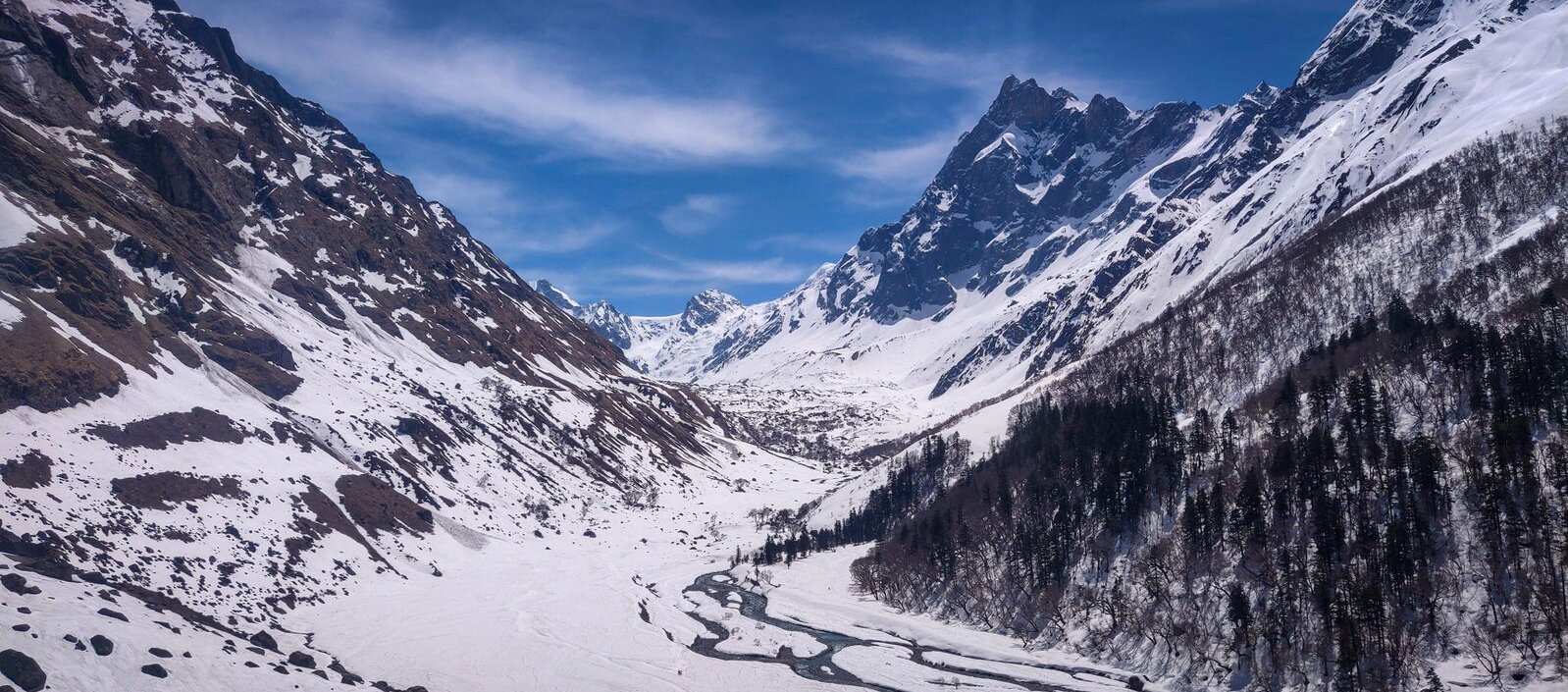
Imagine standing at 4,250 metres, knee-deep in snow, with the entire sweep of Parvati Valley laid out below you in shades of pine green and granite grey. That is the defining moment of the Sar Pass Trek — and it is a moment that tens of thousands of trekkers chase every May and June. Stretching approximately 49 km through the heart of Himachal Pradesh, the Sar Pass Trek takes you from the backpacker haven of Kasol through dense deodar forests, past charming Grahan village, and up through alpine meadows and snow slopes to the 4,250 m pass before descending to Barshaini. The standard itinerary runs 5–6 days and is graded moderate, making it one of the most accessible high-altitude snow treks in India. Whether you are joining a YHAI batch or heading out with a private operator, this 2026 guide covers everything you need to know.
The Sar Pass Trek punches well above its weight for a moderate-grade route. Here is why it consistently tops bucket lists:
- Snow in May and June. While most Indian hill stations are snow-free by April, Sar Pass retains generous snow coverage on the upper slopes and the pass itself well into June, giving trekkers a true winter-in-summer experience.
- Parvati Valley landscapes. The trail passes through some of the most photogenic terrain in Himachal — cascading streams, rhododendron-lined paths, and vast meadows (thachs) ringed by 5,000 m+ peaks.
- Beginner-friendly structure. YHAI (Youth Hostels Association of India) has run organised batches on this route for decades, providing tents, meals, guides, and group accountability — ideal for first-timers who want a safety net without sacrificing adventure.
- Iconic campsites. Biskeri Thach and Min Thach are among the most scenic high-altitude camping spots in the western Himalayas.
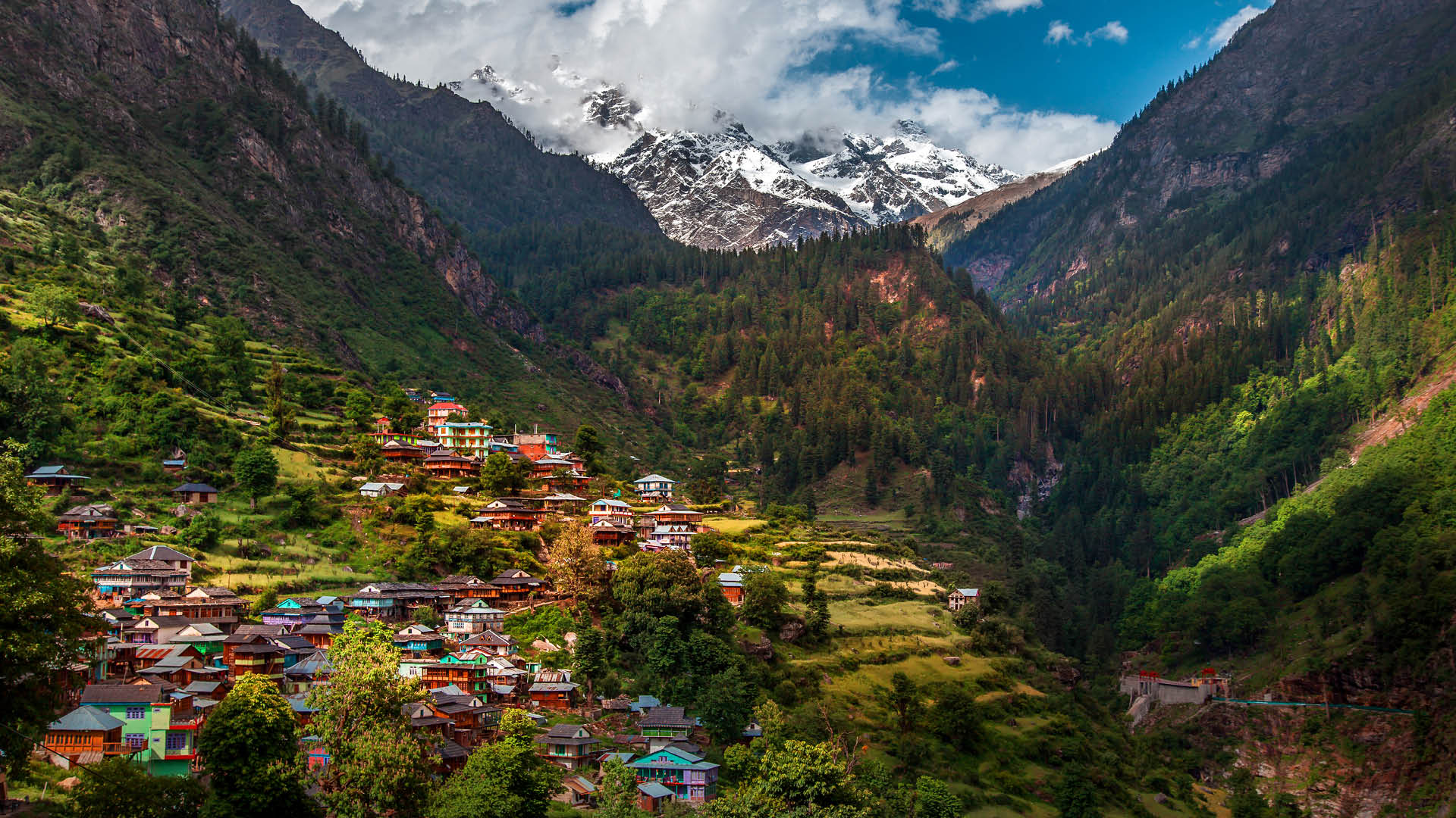
- Cultural proximity to Kasol. The trek starts and ends near Kasol, giving trekkers easy access to the valley's café culture, hot springs at Kheerganga, and the broader Parvati Valley experience.
- Thriving trekking community. The route is especially popular among college groups and young trekkers, creating an energetic, social trail atmosphere.
For more options in the region, see our guide to the best treks in Himachal Pradesh.
At a glance
The route at a glance
The trail follows a logical loop through Parvati Valley, beginning and ending near Kasol. The full route runs: Kasol → Grahan → Min Thach → Nagaru → Sar Pass → Biskeri Thach → Barshaini, with a short drive or walk back to Kasol from Barshaini.
Total distance: ~49 km
Starting altitude: ~1,580 m (Kasol)
Maximum altitude: ~4,250 m (Sar Pass)
Finishing altitude: ~1,850 m (Barshaini)
Terrain types:
- Kasol to Grahan: stone-paved village trail, dense pine and deodar forest
- Grahan to Min Thach: forest gives way to open alpine meadows, stream crossings
- Min Thach to Nagaru: steep ascent, patchy snow from mid-May
- Nagaru to Sar Pass: continuous snow slopes, crampons/gaiters essential
- Sar Pass to Biskeri Thach: thrilling snow descent, then grassy meadow
- Biskeri Thach to Barshaini: long forest descent, river valley trail
A printed or downloaded Sar Pass trek map is strongly recommended; the trail is well-marked in season but can be obscured by snow above Nagaru. Explore the broader Kasol area before or after your trek.
Elevation Profile & Key Checkpoints
| Campsite | Altitude |
|---|---|
| Kasol (start) | 1,580 m |
| Grahan Village | 2,390 m |
| Min Thach | 3,150 m |
| Nagaru | 3,600 m |
| Sar Pass (summit) | 4,250 m |
| Biskeri Thach | 2,900 m |
| Barshaini (end) | 1,850 m |
What each day actually looks like
The standard itinerary is 5 trekking days. YHAI often adds an arrival day at Kasol, making it a 6-day programme overall.
Day 1: Kasol to Grahan — 7 km, 4–5 hours
Elevation gain: +810 m
The trek begins with a river crossing on a footbridge at Kasol and climbs steadily through thick pine forest. Grahan is a traditional Himachali village sitting above the Parvati River — a perfect gentle opener to ease legs into mountain terrain. Overnight camp or guesthouse at Grahan.
Day 2: Grahan to Min Thach — 6 km, 5–6 hours
Elevation gain: +760 m
This is one of the most scenic days, as the trail leaves the treeline and enters open alpine meadows. The path crosses several streams and gains altitude steadily. Min Thach (approximately 3,150 m) is a wide, grassy camping ground flanked by ridgelines — expect your first views of snow-dusted peaks here.
Day 3: Min Thach to Nagaru — 4 km, 4 hours
Elevation gain: +450 m
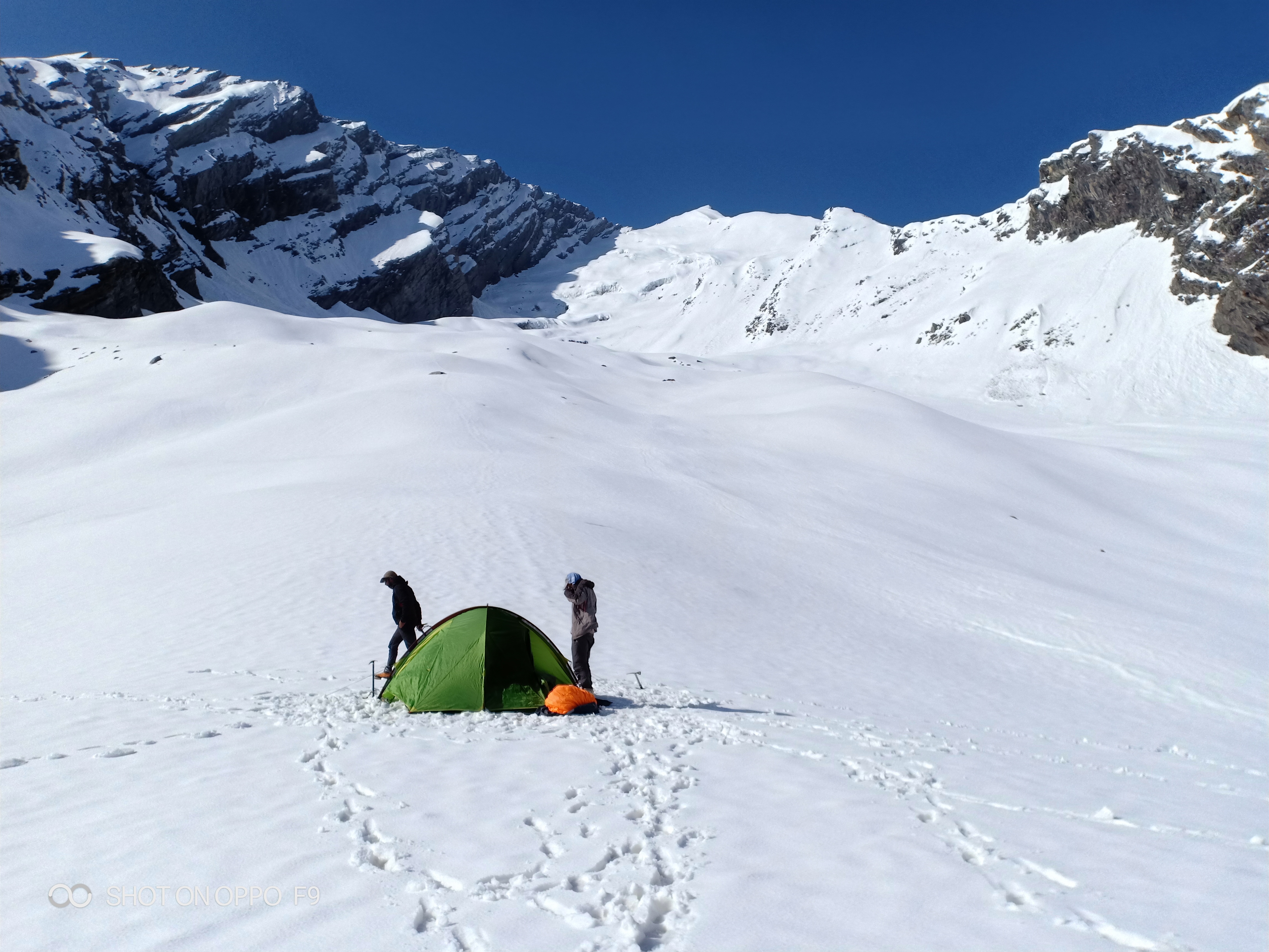
A shorter day by distance, but the gradient sharpens. Snow appears in earnest from around 3,400 m. Nagaru (3,600 m) is a ridge campsite exposed to wind — stake tents securely. This is effectively an acclimatisation day; the limited distance allows your body to adjust before the big summit push. See acclimatisation tips below.
Day 4: Nagaru to Sar Pass to Biskeri Thach — 12 km, 7–8 hours
Elevation gain to pass: +650 m | Elevation loss to Biskeri Thach: -1,350 m
The highlight of the entire trek. An early 4–5 AM start is standard to reach the pass in stable weather before afternoon clouds build. The snow ascent to Sar Pass (4,250 m) is steep and exhilarating — ice axes or trekking poles are essential. The summit rewards with panoramic views across Parvati Valley and towards the Chandrakhani ridge (see our Chandrakhani Pass Trek guide if you want to combine routes). The descent to Biskeri Thach is a long snow slide or steep scramble — one of the most fun sections of any Himalayan moderate trek. Camp at the beautiful Biskeri Thach meadow (2,900 m).
Day 5: Biskeri Thach to Barshaini to Kasol — 14 km, 6–7 hours
Elevation loss: -1,050 m to Barshaini
A long but mostly downhill day through rhododendron and oak forest. Barshaini (1,850 m) is the road-head where most trekkers catch a local bus or shared taxi back to Kasol (approximately 20–30 minutes). The trek concludes at Kasol.
Acclimatisation & Rest Day Tips
- Hydrate constantly. Drink 3–4 litres of water daily above 3,000 m. Avoid alcohol entirely at altitude — it accelerates dehydration and masks AMS symptoms.
- Day 3 is your acclimatisation day. Use the afternoon at Nagaru for a short, light walk 100–200 m above camp, then descend to sleep. The "climb high, sleep low" principle applies.
- Recognise AMS early. Symptoms include persistent headache, nausea, dizziness, loss of appetite, and fatigue. If symptoms worsen, the only correct action is immediate descent. Do not ascend further with AMS. Read our detailed altitude sickness prevention guide.
- No rushing. Walk at a pace where you can hold a conversation — if you cannot, slow down.
When to go
| Season | Months | Conditions | Recommended? |
|---|---|---|---|
| Peak season | May–June | Snow on pass, stable weather, YHAI open | ✅ Best |
| Monsoon | July–August | Heavy rain, slippery trails, landslide risk | ❌ Not recommended |
| Post-monsoon | September–October | Clear skies, reduced snow, limited operators | ⚠️ Possible |
| Winter/closed | November–April | Heavy snow, trail inaccessible | ❌ Closed |
May and June are the undisputed best months for the Sar Pass Trek in 2026. Snow is guaranteed on the pass and upper slopes, wildflowers bloom across Min Thach and Biskeri Thach, and YHAI runs multiple scheduled batches. Temperatures at the pass range from roughly -2°C to +8°C during the day, dropping sharply at night.
Sar Pass trek weather variability is real — afternoon thunderstorms can develop quickly in June. Always start Day 4's summit push before dawn and descend the pass by noon.
The post-monsoon window (September–October) offers crystal-clear skies and excellent visibility but significantly less snow and far fewer organised groups operating. Independent trekkers with experience may prefer this quieter window.
Is this trek right for you?
Grade: Moderate
The Sar Pass Trek is well within reach of first-time Himalayan trekkers, provided they arrive with a baseline of cardiovascular fitness. You do not need prior high-altitude experience, but your body will thank you if you have prepared.
Minimum fitness benchmark:
- Ability to walk 10–14 km/day for 5 consecutive days with a 8–10 kg backpack
- No major cardiac, pulmonary, or orthopaedic conditions
- Comfortable on uneven, rocky, and snow-covered terrain
Recommended 4–6 week training plan:
1. Cardio base: 30–45 minutes of running, cycling, or swimming, 4 days/week
2. Stair climbing: 20–30 floor equivalents with a loaded pack, 3 days/week
3. Long walks: One 15–20 km walk per week on varied terrain
4. Strength: Leg squats, lunges, and core exercises twice weekly
For a complete preparation guide, see our beginner's guide to Himalayan trekking.
YHAI age restriction: YHAI batches accept participants aged 18–35 years. Private operators typically have more flexible age policies; check directly with your chosen operator. Minors may join with guardian consent on private packages.
What permits you need
The Sar Pass Trek does not require an Inner Line Permit (ILP). However, a basic forest/entry permit is mandatory.
- For YHAI trekkers: YHAI handles all group permits as part of the package registration. No separate action needed.
- For private operator trekkers: Reputable operators arrange permits on your behalf.
- For solo/independent trekkers: Register and obtain a permit at the Kasol Forest Checkpost before departure. Carry a valid government-issued photo ID (Aadhaar card or passport).
Permit cost: Approximately ₹100–₹200 per person.
2026 regulation note: The Himachal Pradesh Forest Department has periodically updated entry norms for popular trails in Parvati Valley. As of early 2026, mandatory registration for all trekkers — including those on organised tours — is being enforced at the Kasol checkpost. Carry physical and digital copies of your permit at all times on the trail.
What this trek will cost you
DIY Cost Breakdown (Per Person)
| Item | Estimated Cost (₹) |
|---|---|
| Delhi–Kasol bus (one way) | ₹600–₹1,200 |
| Kasol–Barshaini local transport | ₹50–₹100 |
| Food on trail (₹400/day × 5 days) | ₹2,000 |
| Camping gear rental (tent, sleeping bag, poles) | ₹500–₹1,000/day |
| Local guide | ₹800–₹1,200/day |
| Forest entry permit | ~₹200 |
| DIY Total Estimate | ₹6,000–₹10,000 |
Note: DIY cost assumes you carry your own food supplies for some days and hire a local guide from Kasol or Grahan.
Organised Package Costs
| Option | Cost (Per Person) | Includes |
|---|---|---|
| YHAI Package | ₹8,000–₹12,000 | Food, tent, guide, permit, basic insurance |
| Private Operator | ₹10,000–₹18,000 | Food, tent, guide, transport, permit |
YHAI vs. Private Operator vs. DIY — Which to Choose?
| Factor | YHAI | Private Operator | DIY |
|---|---|---|---|
| Cost | ★★★★★ Lowest | ★★★ Mid-range | ★★★★ Low |
| Flexibility | ★★ Fixed dates/batches | ★★★★ Customisable | ★★★★★ Fully flexible |
| Age restriction | 18–35 years | Typically 16–55+ | No restriction |
| Beginner suitability | ★★★★★ Excellent | ★★★★ Good | ★★ Requires experience |
| Group size | 20–40 per batch | 8–20 | Solo or self-organised |
| Recommended for | First-timers, budget trekkers | Families, customised itineraries | Experienced trekkers with local knowledge |
What to pack
Packing correctly for Sar Pass is non-negotiable — conditions above 3,500 m can turn wintry even in June. (See our detailed what to pack for a Himalayan trek guide for a complete checklist.)
Clothing
- Thermal base layers (top and bottom), at least 2 sets
- Fleece mid-layer
- Waterproof and windproof outer jacket
- Trekking pants (convertible recommended)
- Warm gloves and liner gloves
- Balaclava or buff
- Woollen hat
- Lightweight camp shoes or sandals
Footwear
- Ankle-support waterproof trekking boots (broken in before the trek)
- Gaiters (essential above Nagaru for snow)
- 3–4 pairs of moisture-wicking wool trekking socks
Gear
- 45–60L backpack with rain cover
- Trekking poles (collapsible, 2 recommended)
- Headlamp with spare batteries
- UV-protection sunglasses (glacial UV is intense)
- Sleeping bag rated to -10°C minimum
- Lightweight camp towel
- Dry bags or zip-lock bags for electronics and documents
Toiletries & Medical
- Sunscreen SPF 50+ (reapply every 2 hours on snow)
- Lip balm with SPF
- AMS medication: Diamox (Acetazolamide) — consult your doctor before use
- ORS sachets (at least 10)
- Basic first-aid kit (bandages, antiseptic, blister pads, ibuprofen, antihistamine)
- Water purification tablets or filter
Documents
- Original government-issued photo ID (Aadhaar/passport)
- Copies of permits
- Emergency contact list (printed)
- Travel insurance documents (strongly recommended — ensure policy covers high-altitude trekking and helicopter evacuation)
Affiliate trigger note: Gear links to sleeping bags, trekking poles, and waterproof jackets can be embedded here.
Recommended gear for this trek
Staying safe on the mountain
Safety on Sar Pass is a shared responsibility between you, your guide, and your group.
Altitude & AMS
- Learn the symptoms: headache, nausea, dizziness, confusion, difficulty breathing at rest
- Never ascend further if you have AMS symptoms — descend immediately by at least 500 m
- Carry Diamox but do not rely on it as a substitute for proper acclimatisation
Weather
- Mountain weather changes rapidly — afternoon thunderstorms are common in June
- Always carry a rain cover for your backpack and a poncho/rain jacket on your person, not buried in your bag
- Check weather forecasts at Kasol before Day 4's summit attempt
Trail safety
- Stay on marked trails; above Nagaru, snow can obscure the path entirely
- Trek in groups of at least 3; never hike alone, especially on summit day
- Inform your campsite manager or YHAI coordinator of your daily departure time and expected arrival
- Avalanche risk: Late-season snowfall (mid-June onwards) can increase avalanche risk on the Nagaru–Sar Pass slope — follow your guide's assessment
Connectivity
- Mobile network coverage is limited beyond Grahan village; BSNL has the most reliable (though weak) signal
- Download offline maps (Maps.me or Gaia GPS) before leaving Kasol
- Carry a fully charged power bank
General
- No alcohol above 2,500 m
- Do not litter — carry all non-biodegradable waste back to Kasol
- Respect local customs in Grahan village
Emergency Contacts & Evacuation Routes
| Resource | Details |
|---|---|
| Kasol Police Station | 01902-265243 |
| Bhuntar Civil Hospital | ~30 km from Kasol via NH3 |
| YHAI Emergency Line | Contact your batch leader / YHAI regional office |
| Helicopter Evacuation | Triggered for severe AMS, HACE, HAPE, or major injury — coordinate via Kasol Police or YHAI |
Nearest hospital: Bhuntar Civil Hospital (Dr. Rajendra Prasad Government Medical College referrals for serious cases).
Primary evacuation route: In case of emergency below Nagaru, the fastest evacuation is back to Grahan and then Kasol via the entry trail. Above Nagaru, descent to Biskeri Thach and out via Barshaini may be faster depending on conditions.
Similar treks to explore
Kugti Pass Trek: Guide to Himachal's Hidden Crossing
The Kugti Pass trek is a difficult high-altitude crossing in Chamba, Himachal Pradesh, reaching ~4,920 m (16,142 ft) and connecting Chamba to Lahaul.
Friendship Peak Base Trek: Complete 2026 Guide
The Friendship Peak Base Trek is a 5–6 day moderate-to-difficult trek in Himachal Pradesh, starting at Dhundi (2480m) near Manali and reaching base camp at 4800–5000m beneath the 5289m summit.
Tosh Valley Trek: Guide to Parvati Valley's Hidden Gem
The Tosh Valley trek is a 3–4 km hike from Barshaini to Tosh Village (2,400 m) in Himachal Pradesh's Parvati Valley, rated easy to moderate and best done April–June.
Common questions answered
Yes. The Sar Pass Trek is graded moderate and is one of the most popular first Himalayan treks in India. No prior high-altitude experience is required, though basic cardiovascular fitness is essential. YHAI's structured group batches — with guides, fixed campsites, and meals included — make it particularly well-suited for beginners who want the security of an organised programme.