Why Shrikhand Mahadev Trek is on every trekker's list
Some mountains demand respect. Shrikhand Mahadev demands devotion — and then some. Rising to 5,227 metres (17,149 feet) in the Kullu district of Himachal Pradesh, this remote Himalayan peak is home to one of Hinduism's most revered natural Shiva lingams, believed by millions to be the abode of Lord Shiva himself. Every year, during a narrow window in the heart of the monsoon season, thousands of pilgrims and adventure trekkers brave glacial snowfields, razor-edged ridgelines, and punishing altitude to earn a moment of darshan at the summit.
The Shrikhand Mahadev trek is not for the faint-hearted. It is graded Extreme by most experienced mountaineering bodies, involves a net altitude gain of over 3,000 metres, and culminates in a summit day of 12–14 hours starting before dawn. Yet year after year, the trail fills with barefoot pilgrims in saffron, seasoned mountaineers with technical gear, and first-timers whose faith outweighs their fitness — a humbling reminder that mountains have their own rules.
If you are planning the 2026 trekking season and want the most accurate, no-nonsense guide to Shrikhand Mahadev, you are in exactly the right place.
Very few treks in the Indian Himalayas manage to fuse extreme adventure with profound spiritual purpose as seamlessly as this one. Here is why it stands apart.
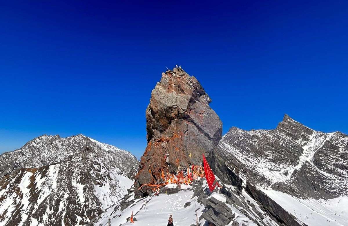
Spiritual significance: The Shiva lingam at the summit is not a man-made structure — it is a naturally occurring rock formation believed to be a manifestation of Lord Shiva. For devout Hindus, reaching it is equivalent to attaining moksha from a lifetime of sins. The annual Shrikhand Yatra, managed by the Shrikhand Mahadev Seva Trust, draws pilgrims from across India and the world, many of whom trek in traditional religious attire, chanting bhajans the entire way.
Scenic grandeur: The trail passes through some of Himachal's most dramatic landscapes — dense cedar and oak forests in the lower sections, sweeping alpine meadows (including the famous Parvati Baag, a floral high-altitude garden), glacial snowfields above Kaali Ghati, and the ethereal Nain Sarovar, a glacial lake just below the summit. On a clear morning, views extend across the Kullu valley, the Parvati range, and deep into the Spiti horizon.
Cultural depth: Unlike commercially driven treks, Shrikhand Mahadev retains an authenticity rare in modern Himalayan tourism. Local Himachali culture, folk rituals at Bheem Dwar, and the communal spirit of the Yatra create an experience that is as culturally immersive as it is physically gruelling.
The challenge itself: If you have done Kedarkantha, Hampta Pass, or even Stok Kangri and are looking for the next level, Shrikhand Mahadev is the honest answer. The summit day alone — 10 km on glacial terrain starting at 2–3 AM — is among the most demanding single-day pushes on any non-technical Himalayan route.
For more context on where this sits among regional routes, see our guide to the best treks in Himachal Pradesh.
At a glance
The route at a glance
The trek begins at Jaon village in Nirmand tehsil, Kullu district, sitting at approximately 2,200 metres. From here, the trail climbs relentlessly through five distinct ecological and terrain zones before reaching the summit at 5,227 metres.
The one-way distance is approximately 32–35 kilometres, making the full round trip roughly 65–70 kilometres over 5–6 days. Terrain transitions sharply: the lower sections wind through mixed Himalayan forest; mid-sections open into rocky moraines and boulder fields; above Kaali Ghati (4,500 m) the trail crosses glacial snowfields that persist well into August; and the final push to the summit involves steep rocky scrambles requiring hands and feet.
Key waypoints in order: Jaon → Singhad → Thachru → Kaali Ghati → Bheem Dwar → Parvati Baag → Nain Sarovar → Shrikhand Mahadev Summit.
The Himachal Pradesh Forest Department maintains check posts at several points along the route, and the Seva Trust operates support structures including temporary camps and medical posts during the Yatra window.
Shrikhand Mahadev Trek Distance and Altitude Profile
| Waypoint | Altitude (metres) | Approx. Cumulative Distance from Jaon |
|---|---|---|
| Jaon Village (Start) | 2,200 m | 0 km |
| Singhad | 2,750 m | ~4 km |
| Thachru | 3,450 m | ~12 km |
| Kaali Ghati | 4,500 m | ~18 km |
| Bheem Dwar | 4,900 m | ~22 km |
| Parvati Baag | 5,100 m | ~28 km |
| Shrikhand Mahadev Peak | 5,227 m | ~32–35 km |
The elevation profile is a near-continuous ascent with no significant descents until the return journey, meaning acclimatisation strategy matters enormously. Read our guide on how to acclimatise for Himalayan treks before departure.
What each day actually looks like
The following 6-day itinerary is designed for the 2026 Yatra season. It includes a buffer day and assumes you begin your journey from Shimla or Bhuntar.
Day 1: Drive to Jaon Village and Acclimatisation
Route: Shimla or Bhuntar → Nirmand → Jaon Village
Drive distance: ~220 km from Shimla (approx. 7–9 hours); ~130 km from Bhuntar near Kullu (approx. 4–5 hours)
Altitude: Arrive at 2,200 m
Activity: Travel day + rest
Jaon is a small, traditionally Himachali village that transforms into a buzzing base camp during the Yatra season. On arrival, complete your mandatory registration at the check post managed by the HP Forest Department and Shrikhand Mahadev Seva Trust. Carry your Aadhar card or valid government ID and a medical fitness certificate.
Spend the afternoon visiting the local temple, hydrating well, and sorting your gear. Avoid alcohol entirely for the duration of the trek. Overnight at Jaon in a guesthouse, tent, or community dharamshala.
For road trip planning, see our Shimla to Kullu road trip guide.
Day 2: Jaon to Thachru
Distance: ~12 km
Altitude: 2,200 m → 3,450 m (gain: ~1,250 m)
Duration: 6–7 hours
Camp: Thachru meadows
This is a long but relatively straightforward day through dense Himalayan forest. The trail passes through Singhad (2,750 m) at around the 4 km mark — a good spot for a short rest and snack. Beyond Singhad, the tree cover begins to thin and the valley opens up.
Thachru is a wide alpine meadow at 3,450 m and the main established campsite on the route. During the Yatra, you will find temporary tea stalls and food vendors here. Set up camp early, eat a warm meal, and sleep by 8 PM. Altitude will begin to be felt by some trekkers here — monitor for headaches.
Day 3: Thachru to Kaali Ghati and Bheem Dwar
Distance: ~10 km
Altitude: 3,450 m → 4,900 m (gain: ~1,450 m)
Duration: 7–9 hours
Camp: Bheem Dwar
This is arguably the hardest day of the trek before the summit push. The terrain shifts dramatically above Thachru — forest gives way to rocky moraine, and by the time you approach Kaali Ghati (4,500 m), you are navigating steep boulder fields and often snow-covered slopes even in July.
Kaali Ghati is a narrow, exposed pass that requires care in wet or icy conditions. Take your time here; rushing is dangerous. Beyond Kaali Ghati, the trail descends slightly before climbing again to Bheem Dwar (4,900 m), the last major halt before the summit.
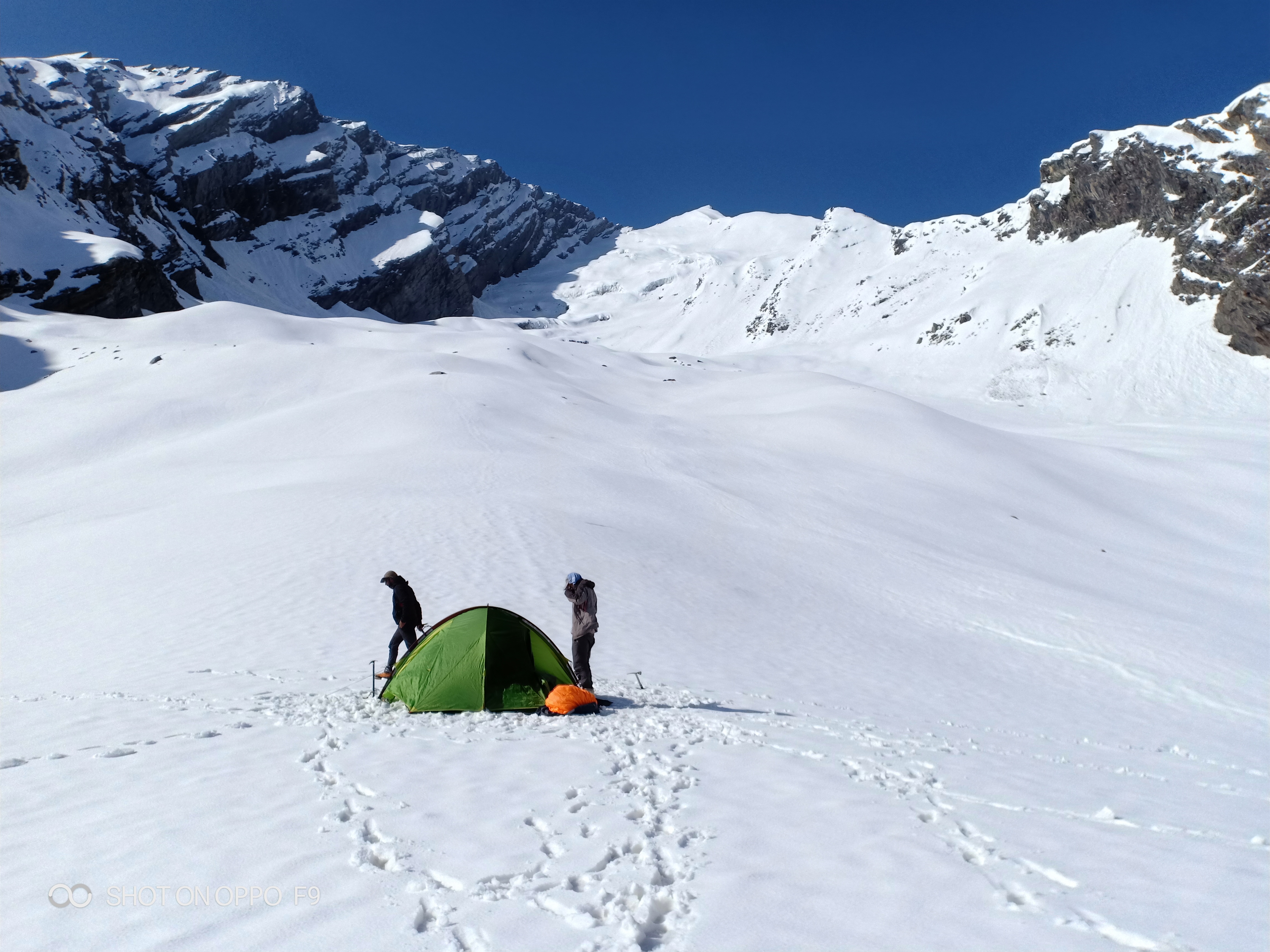
Bheem Dwar has deep mythological significance — according to local legend, the Pandavas rested here during their own pilgrimage. A small shrine and temporary medical post (operated by the Seva Trust during Yatra) are located here. Rest well and eat adequately. Tomorrow's summit day begins before sunrise.
Day 4: Summit Day — Bheem Dwar to Shrikhand Mahadev and Back to Thachru
Distance: ~10 km one way to summit; return to Thachru adds ~12 km descent
Altitude: 4,900 m → 5,227 m → descent to 3,450 m
Duration: 12–14 hours total
Start time: 2:00–3:00 AM
Set your alarm for 1:30 AM. This is the day everything has been building towards.
The predawn start is non-negotiable — you need to reach the summit and begin your descent before afternoon clouds and potential thunderstorms roll in (typically after midday in the monsoon window). The safe weather window at the summit is roughly 6–10 AM.
From Bheem Dwar, the trail climbs through Parvati Baag (5,100 m), a high-altitude meadow that, on a clear morning, is carpeted with alpine wildflowers and surrounded by glacial walls — one of the most otherworldly sights in the Indian Himalayas. Beyond Parvati Baag, you reach Nain Sarovar, a sacred glacial lake. Many pilgrims perform a ritual dip here regardless of temperature.
The final section to the summit is a steep, exposed rocky scramble. Trekking poles are essential. At 5,227 metres, the natural Shiva lingam emerges from the rock — draped in offerings, surrounded by devotees, and set against a panorama of the Western Himalayas that will stop you in your tracks.
After darshan, begin your descent immediately. Do not linger above 5,000 m in deteriorating weather. Descend all the way to Thachru (3,450 m) for the night — the significant drop in altitude is important for recovery.
Day 5: Thachru to Jaon
Distance: ~12 km
Altitude: 3,450 m → 2,200 m
Duration: 5–6 hours
Overnight: Jaon village or drive back
A relatively comfortable descent on familiar terrain. Your legs will feel the cumulative effort of the previous days, so use trekking poles and take care on slippery or rooted sections. Complete any exit formalities at the Jaon check post. Celebrate with a hot meal in the village.
Depending on your transport arrangement, you may drive back to Shimla or Bhuntar this evening or overnight in Jaon.
Day 6: Buffer / Departure
This day is built in as a buffer for bad weather, fatigue, or delayed summit attempts. Mountain weather is unpredictable, and the Shrikhand Mahadev summit day is frequently postponed by a day due to overnight snowfall or visibility issues. If all has gone to plan, use this day for the drive back to Shimla or Bhuntar for onward connections.
When to go
The Shrikhand Mahadev trek has one of the most restricted seasonal windows of any major Himalayan route: mid-July to mid-August only.
This is not merely a recommendation — it is the only period when the route is officially open and safe. The annual Shrikhand Yatra dates are announced each year by the Shrikhand Mahadev Seva Trust, typically in June. In 2026, the Yatra window is expected to fall within this mid-July to mid-August range — confirm exact dates with the Seva Trust as the season approaches, as dates can shift by a few days year to year.
Why only this window? The route sits in a high-altitude zone that remains buried under several metres of snow from September through June. By mid-July, the summer sun has cleared enough snow for safe passage on the critical sections above Kaali Ghati. By mid-August, early pre-winter snowfall and unstable monsoon weather make the glacial sections above 4,500 m extremely hazardous.
Attempting the trek outside this window — even in late August — is strongly discouraged and not permitted by authorities. The route is not accessible, and rescue operations above 4,000 m in unseasonal snowfall are extremely difficult.
Is this trek right for you?
Grade: Very Difficult / Extreme
This is not a marketing label. The Shrikhand Mahadev trek earns its extreme classification through a combination of factors that individually would each make a trek hard — combined, they create one of India's most unforgiving routes:
- Net altitude gain of ~3,000 metres from base to summit
- Glacial terrain above 4,500 m requiring careful foot placement
- High Acute Mountain Sickness (AMS) risk due to rapid elevation gain, especially between Thachru and Bheem Dwar
- Summit day duration of 12–14 hours with a 2–3 AM start
- Monsoon-season conditions — wet rocks, low visibility patches, and sudden weather changes
Recommended fitness preparation (minimum 3 months before trek):
- Daily cardio: running, cycling, or swimming (45–60 minutes)
- Stair climbing with a loaded backpack (10–12 kg)
- Weekend hikes of 15–20 km with elevation
- Core and leg strength training
Prior experience: No prior 5,000 m experience is strictly mandated, but it is strongly advised. Trekkers who have completed routes such as Kinner Kailash or high-altitude passes above 4,500 m will be significantly better prepared.
Age and medical considerations: Most operators and the Seva Trust recommend trekkers be between 14–60 years of age. Those with cardiac conditions, respiratory issues, uncontrolled hypertension, or a history of severe AMS should not attempt this trek without explicit medical clearance. Consult a doctor familiar with high-altitude medicine before departure.
See also: High-altitude trekking tips for India.
What permits you need
Registration for the Shrikhand Mahadev trek is mandatory and managed jointly by the Himachal Pradesh Forest Department and the Shrikhand Mahadev Seva Trust.
Where: Physical registration only at the check post in Jaon village. There is currently no online registration system for this trek.
When: Registration opens concurrently with the official Yatra dates each year.
Documents required:
- Valid government-issued photo ID (Aadhar card accepted)
- Medical fitness certificate (can be obtained from a registered doctor; some camps near Jaon offer on-site medical checks during Yatra season)
Permit fee: Approximately INR 100–200 per person.
Daily entry limits: The Seva Trust and Forest Department may impose daily trekker limits during peak Yatra days to manage trail congestion and environmental impact. Arrive at Jaon early in the Yatra window to avoid queues.
What this trek will cost you
DIY Budget (Per Person)
| Expense | Estimated Cost (INR) |
|---|---|
| Transport (Shimla–Jaon–Shimla, shared/bus) | 2,000–3,500 |
| Trek permit | 100–200 |
| Food and camping (5 days, basic dhabas + own supplies) | 1,500–2,500 |
| Porter or guide (INR 800–1,200/day × 4–5 days) | 3,200–6,000 |
| Total DIY estimate | ~6,800–12,200 |
Note: Hiring a local guide is strongly recommended given the glacial terrain and navigation challenges above Kaali Ghati. This is a safety cost, not a luxury.
Organised Package (Per Person)
Operators offering packages for the 2026 Shrikhand Yatra typically charge INR 12,000–20,000 per person, which generally includes:
- Return transport from Shimla or Kullu/Bhuntar
- All meals during the trek
- Camping equipment (tent, sleeping mat)
- Experienced guide and support staff
- Basic first-aid and oxygen cylinder
- Permit assistance
Important: Organised packages fill quickly once Yatra dates are announced. If you are going with an operator, book as soon as dates are confirmed — ideally in June 2026.
All cost figures are 2026 estimates. Fuel prices, transport fares, and operator rates can vary. Verify with operators and local transport providers closer to your travel date.
What to pack
Packing right for Shrikhand Mahadev can be the difference between a successful summit and an emergency evacuation. The monsoon-season timing means you must prepare for both intense sun and sudden cold, wet conditions.
Clothing (layering system):
- Moisture-wicking base layer (thermal weight)
- Mid-layer fleece or down jacket
- Waterproof and windproof outer shell
- Trekking trousers (quick-dry)
- Warm hat and balaclava
- Gloves (liner + outer waterproof)
- Gaiters (essential for snow sections above Kaali Ghati)
Footwear:
- Sturdy ankle-support trekking boots (waterproof; broken in before the trek)
- Warm trekking socks × 3–4 pairs
- Camp sandals or crocs
Equipment:
- Trekking poles × 2 (collapsible)
- Sleeping bag rated to -10°C (the nights at Bheem Dwar are brutal)
- Headlamp with spare batteries (critical for 2 AM summit start)
- Rain poncho or pack cover
- 30–35 litre daypack + 50–60 litre main pack (if not using porter)
- Water bottles or hydration bladder (3-litre capacity minimum)
- Water purification tablets
Sun and weather protection:
- Sunscreen SPF 50+ (reapply every 2 hours above 4,000 m)
- UV400 sunglasses (snow blindness is a real risk)
- Lip balm with SPF
Medical kit:
- Diamox (Acetazolamide) — consult your doctor before the trek; standard AMS prevention protocol. See our altitude sickness prevention guide.
- ORS sachets (× 10+)
- Ibuprofen and paracetamol
- Blister pads and antiseptic cream
- Bandages and medical tape
- Personal prescription medications
Documents and miscellaneous:
- Original ID + 2 photocopies
- Permit copy
- Emergency contact list (physical copy)
- Cash in small denominations (no ATMs beyond Nirmand)
- Energy bars, trail mix, dry fruits, electrolyte powder
- Whistle and emergency space blanket (bivvy)
Leave behind above Kaali Ghati: Heavy camera tripods, DSLR bodies with large lenses, or any non-essential weight. Every 100 grams matters above 4,500 m.
For a complete gear reference, see our trekking gear checklist for India.
Recommended gear for this trek
Staying safe on the mountain
AMS is the number one risk on this trek. The rapid ascent from 2,200 m to 4,900 m over just three days gives your body very little time to adapt. Know the symptoms: persistent headache, nausea, vomiting, loss of appetite, dizziness, and fatigue that does not resolve with rest. If symptoms are severe — confusion, loss of coordination, chest tightness, or frothy cough — descend immediately. Do not wait for morning.
Key safety guidelines:
- Hydrate aggressively: Minimum 3–4 litres of water per day throughout the trek, more on summit day.
- Never trek alone above Thachru. The terrain above 3,500 m demands a partner or guide at minimum.
- Summit weather window: Aim to reach the summit between 6–10 AM. Afternoon thunderstorms during the monsoon can arrive with little warning.
- Do not push through severe AMS. The summit will be there next year. Your life will not be if you ignore symptoms at 4,900 m.
- Inform your family: Leave a detailed itinerary — dates, campsites, emergency contacts — with a trusted person before departure.
- Emergency contacts:
- Kullu District Hospital: +91-1902-222341 (verify this number is current before travel)
- Local rescue coordination at Bheem Dwar (Seva Trust staff present during Yatra) - Helicopter rescue: In serious emergencies, helicopter evacuation is possible from the Jaon area. This is expensive and weather-dependent — travel insurance covering high-altitude rescue is strongly recommended.
- Zero-waste rule: Himachal Pradesh's Green Fee rules and the Seva Trust's guidelines prohibit littering on the trail. Pack out all waste. The Parvati Baag and Nain Sarovar areas are ecologically fragile.
- Fire safety: No open fires above the tree line. Use stoves only.
For detailed AMS protocols, read our altitude sickness prevention guide and high-altitude trekking tips.
Similar treks to explore
Friendship Peak Base Trek: Complete 2026 Guide
The Friendship Peak Base Trek is a 5–6 day moderate-to-difficult trek in Himachal Pradesh, starting at Dhundi (2480m) near Manali and reaching base camp at 4800–5000m beneath the 5289m summit.
Tosh Valley Trek: Guide to Parvati Valley's Hidden Gem
The Tosh Valley trek is a 3–4 km hike from Barshaini to Tosh Village (2,400 m) in Himachal Pradesh's Parvati Valley, rated easy to moderate and best done April–June.

Sar Pass Trek: Complete Guide 2026 (Route & Tips)
Sar Pass Trek is a 49 km moderate Himalayan trek in Himachal Pradesh, reaching 4,250 m, best done May–June over 5–6 days from Kasol to Barshaini.
Common questions answered
Shrikhand Mahadev is classified as one of India's most difficult non-technical treks, graded Extreme by most Himalayan trekking bodies. The combination of extreme altitude (5,227 m), steep glacial terrain above Kaali Ghati, a summit day lasting 12–14 hours beginning at 2–3 AM, and high AMS risk places it firmly in a category suitable only for fit, experienced trekkers. If you have not yet trekked above 4,000 m, build up with routes like the Chandrakhani Pass trek first.