Why Tarsar Marsar Trek is on every trekker's list
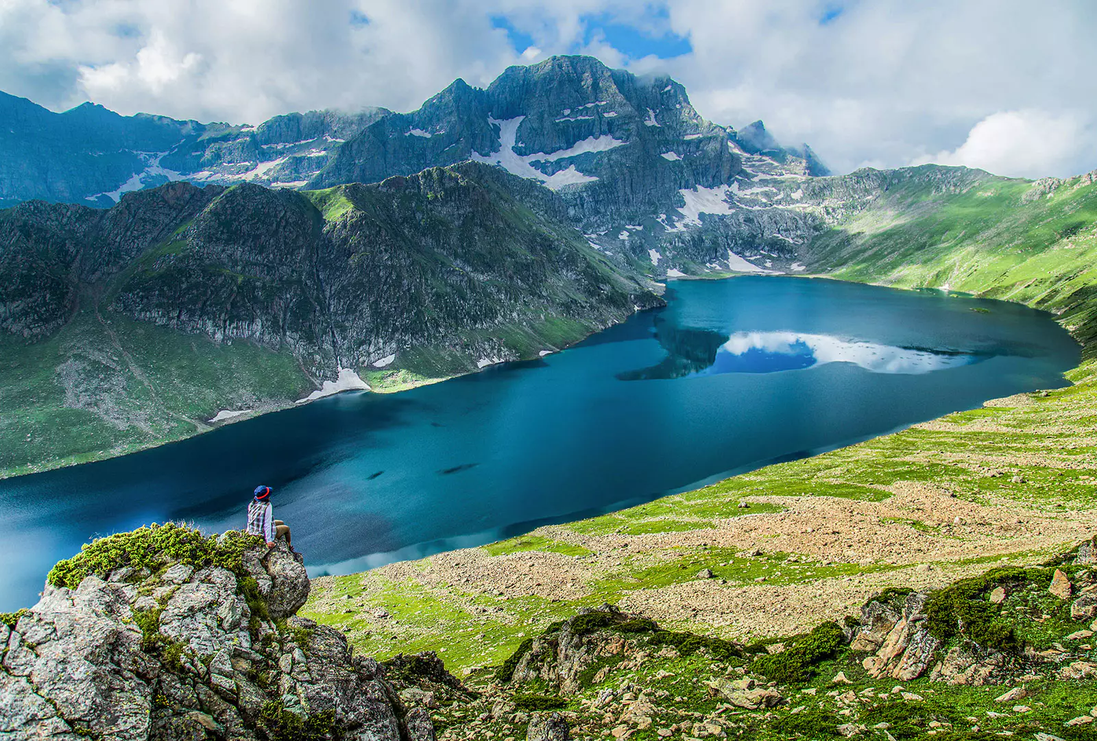
Picture standing at the edge of a perfectly still lake ringed by snow-dusted peaks — the water so vividly turquoise it looks painted. Now picture doing it twice, at two separate lakes, separated by a wind-scoured pass that puts the entire Kashmir Himalaya on display. That is the promise of the Tarsar Marsar Trek.
Nestled in the Pahalgam Wildlife Sanctuary of Anantnag District, this twin-lake circuit begins at Aru Valley (approximately 2,400 m), threads through the shepherd-grazed meadows above the Lidder River, and climbs to Tarsar Lake (≈ 3,800 m) and Marsar Lake (≈ 3,850 m) via Tarsar Pass (≈ 4,100 m). Total trail distance is roughly 50 km, making it a compact but altitude-demanding route that most fit trekkers can complete in 6–7 days.
What sets this trek apart in a region overflowing with great walks is its intimacy. Unlike the longer Kashmir Great Lakes circuit, the Tarsar Marsar route concentrates its drama: two glacially carved lakes in close succession, meadows thick with Himalayan wildflowers, Bakarwal shepherd camps, and unobstructed views toward the Kolahoi Glacier. If you want the essence of high-altitude Kashmir without the larger crowds, this is your trek.
The Kashmir Himalayas offer dozens of routes, so why pick this one? Here are the reasons trekkers keep returning:
Twin lakes in a single circuit. Very few Himalayan treks let you camp beside two distinct alpine lakes of such character — Tarsar's deep cobalt waters and Marsar's quieter, more remote feel — within the same route.
Comparatively uncrowded. While the Kashmir Great Lakes Trek (see our Kashmir Great Lakes Trek Guide) attracts large commercial groups, Tarsar Marsar still sees a fraction of that footfall in 2026. Early morning at Tarsar Lake, you may have the shore entirely to yourself.
Dramatic meadow landscapes. The trail passes through Lidderwat and Shekwas, alpine meadows carpeted in summer with Himalayan blue poppy, iris, and buttercup. These are also active Bakarwal shepherd grazing grounds, giving the trek an authentic cultural layer.
Accessible trailhead. The trek starts from Aru Valley, just 11 km from Pahalgam by road and 3–4 hours from Srinagar. No internal flights or long jeep safaris required. See our Aru Valley Travel Guide and Pahalgam Travel Guide for base-town logistics.
Manageable duration. At 6–7 days, the trek fits a standard one-week holiday — something the 8–9 day Kashmir Great Lakes circuit cannot always offer.
Tarsar Marsar vs Kashmir Great Lakes: Which Trek Is Right for You?
| Factor | Tarsar Marsar Trek | Kashmir Great Lakes Trek |
|---|---|---|
| Duration | 6–7 days | 8–9 days |
| Distance | ~50 km | ~70–75 km |
| Difficulty | Moderate–Difficult | Difficult |
| Max elevation | ~4,100 m (Tarsar Pass) | ~4,300 m+ |
| Lakes visited | 2 (Tarsar, Marsar) | 7+ (Vishansar, Krishansar, Gangabal, etc.) |
| Crowd level (2026) | Low–Moderate | Moderate–High |
| Best for | Intermediate trekkers, limited time | Experienced trekkers seeking a grand traverse |
| Starting point | Aru Valley, Pahalgam | Sonamarg or Naranag |
Verdict: Choose Tarsar Marsar if you have a week, prefer solitude, and want your first serious Kashmir high-altitude experience. Choose Kashmir Great Lakes for a longer, more varied traverse across the Kashmir alpine zone.
At a glance
The route at a glance
The trek follows the Lidder River valley upstream from Aru, gains the high pastoral basin around Lidderwat and Shekwas, then climbs steeply to the Tarsar Lake cirque before crossing Tarsar Pass to reach the remote Marsar basin. The descent loops back to Aru via the Homwas and Satlanjan meadows, making it a true circuit rather than an out-and-back.
Trailhead: Aru Village, Aru Valley, Pahalgam (approx. 2,400 m)
Key waypoints:
1. Lidderwat meadows (~3,175 m)
2. Shekwas (~3,400 m)
3. Tarsar Lake (~3,800 m)
4. Tarsar Pass (~4,100 m)
5. Marsar Lake (~3,850 m)
6. Homwas / Satlanjan (~3,200 m)
7. Return to Aru (~2,400 m)
The route stays within Pahalgam Wildlife Sanctuary for most of its length, which is why a Forest Department entry permit is mandatory. The proximity to Kolahoi Glacier (visible from higher camps) adds a glaciological grandeur to the eastern horizon. The Lidder River — which originates near Kolahoi — is audible for much of Days 1–2.
Note: A route map showing the circuit, pass, and campsite positions is displayed on the TrekYatra interactive map widget above this article.
Tarsar Marsar Trek Elevation Profile and Key Distances
| Day | Segment | Start Elevation (m) | End Elevation (m) | Distance (km) | Approx. Gain/Loss |
|---|---|---|---|---|---|
| 1 | Aru → Lidderwat | 2,400 | 3,175 | 11 | +775 m |
| 2 | Lidderwat → Shekwas | 3,175 | 3,400 | 8 | +225 m |
| 3 | Shekwas → Tarsar Lake | 3,400 | 3,800 | 6 | +400 m |
| 4 | Tarsar → Tarsar Pass → Marsar | 3,800 | 4,100 → 3,850 | 8 | +300 m / −250 m |
| 5 | Marsar → Homwas/Satlanjan | 3,850 | 3,200 | 7 | −650 m |
| 6 | Homwas → Aru | 3,200 | 2,400 | 10 | −800 m |
| 7 | Buffer / Departure | — | — | — | — |
What each day actually looks like
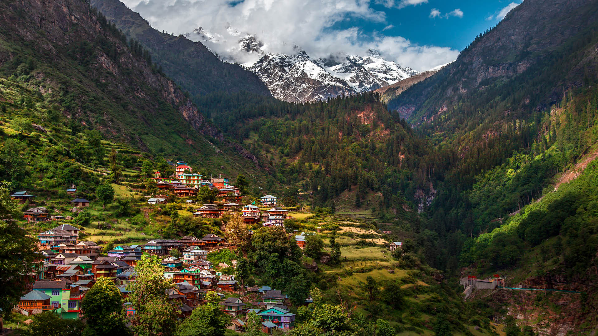
Day 1 — Pahalgam to Aru, then Trek to Lidderwat (11 km | ~5–6 hrs | Camp at 3,175 m)
Arrive in Pahalgam the previous evening and overnight there (see Pahalgam Travel Guide for hotel options). After breakfast, drive 11 km to Aru Village (2,400 m) — about 30–40 minutes by taxi or shared cab. Collect your Forest Department permit at the Aru checkpost before setting out.
The trail follows the left bank of the Lidder River through pine and fir forest before opening into broad glacial meadows. The path is well-defined and used by local shepherds. Lidderwat is a sprawling meadow camp with a mountain rescue post; tents and basic dhabas are usually available in season.
Highlights: Dense conifer forest, first views of high-altitude ridgelines, shepherd settlements, Lidder River crossings on wooden bridges.
Day 2 — Lidderwat to Shekwas (8 km | ~4–5 hrs | Camp at 3,400 m)
A moderate climb above the treeline. The trail steepens after Lidderwat as you gain the upper Lidder valley. Shekwas is a wide, bowl-shaped meadow favoured by Bakarwal herders. Wildflower diversity peaks here in July–August. On clear days, you'll see the first snowfields clinging to the ridgelines ahead.
Highlights: Transition above treeline, Bakarwal camps, first glimpses of snow-capped peaks, Himalayan marmots.
Day 3 — Shekwas to Tarsar Lake (6 km | ~4 hrs | Camp at 3,800 m)
The shortest day in distance but psychologically the most rewarding. A sustained climb through boulder fields and late-lying snowfields (in June–July) brings you abruptly to the lip of the Tarsar cirque — and then the lake appears in full. Tarsar Lake is a deep, cold, kidney-shaped body of water backed by a headwall of peaks. Camp on the grassy knolls above the northern shore.
This is the highest camp before the pass. Acclimatise carefully; avoid strenuous afternoon activity. See acclimatisation tips below.
Highlights: Dramatic reveal of Tarsar Lake, reflections of surrounding peaks, possible sightings of Himalayan brown bear in boulder fields (maintain distance).
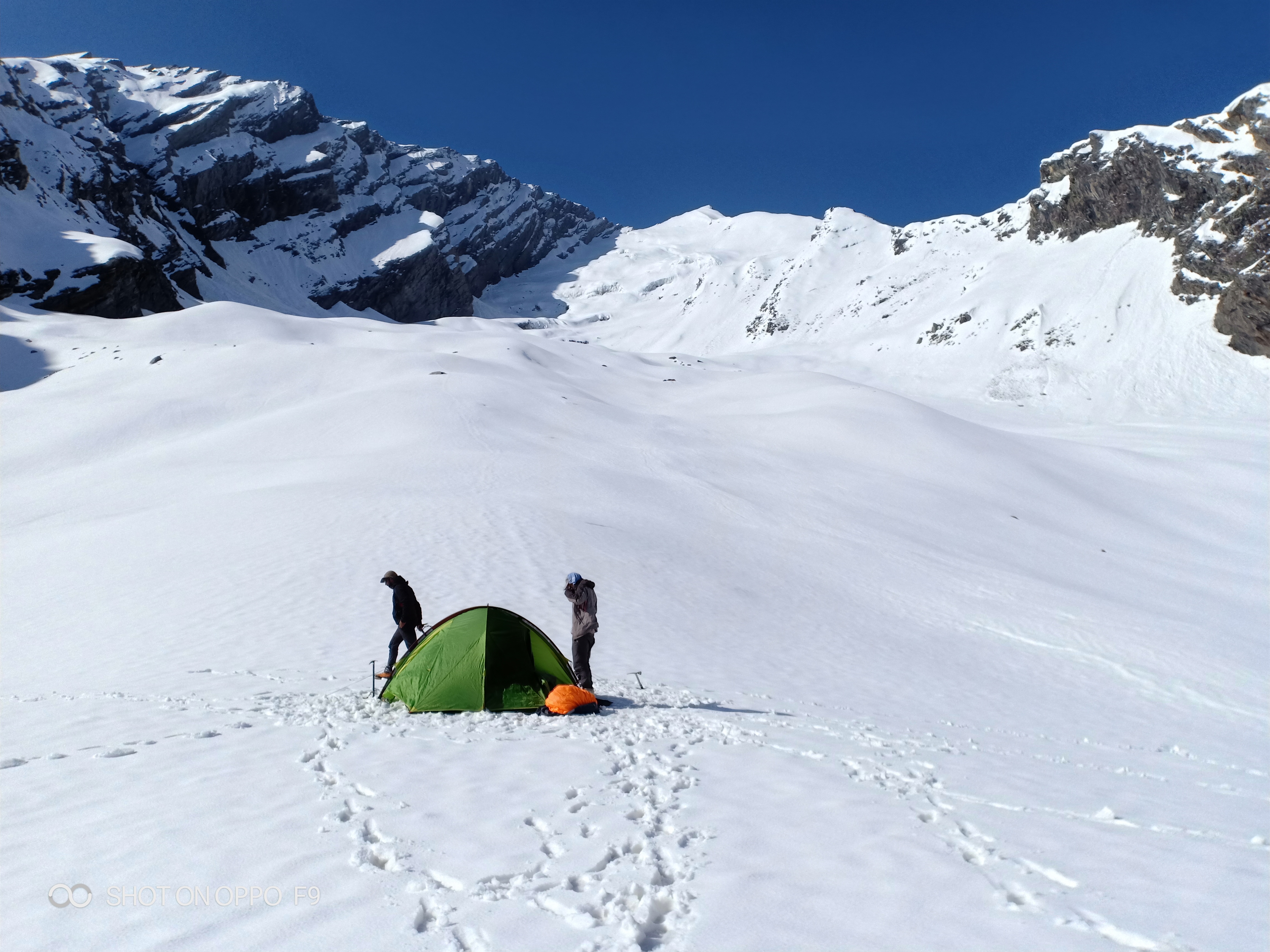
Day 4 — Tarsar Lake to Marsar Lake via Tarsar Pass (8 km | ~6–7 hrs | Camp at 3,850 m)
The most challenging day. You gain roughly 300 m from camp to Tarsar Pass (~4,100 m) on a steep, rocky trail that may hold snow into August. The pass rewards with panoramic views across two valleys. The descent to Marsar Lake is steep and requires care on loose scree.
Marsar sits in a lonelier, more sheltered basin than Tarsar — fewer trekking groups camp here, and the silence is striking. The lake's shores can be marshy; camp on firm ground to the south.
Highlights: Tarsar Pass panorama, potential views toward Kolahoi Glacier, the contrast between Tarsar's grandeur and Marsar's solitude.
Safety note: Do not attempt the pass in poor visibility or after fresh snowfall without an experienced guide.
Day 5 — Marsar Lake to Homwas / Satlanjan (7 km | ~4–5 hrs | Camp at 3,200 m)
A long descending traverse through high pastures. The Homwas and Satlanjan meadows mark the return arc of the circuit. Expect shepherd activity here in summer — a good opportunity to observe Bakarwal culture and perhaps share a cup of kehwa.
Highlights: Long meadow descent, wildflowers, pastoral shepherd life, easing of altitude pressure.
Day 6 — Homwas / Satlanjan to Aru Valley (10 km | ~5–6 hrs | End point 2,400 m)
A satisfying final descent back through forest to Aru Village. The trail rejoins the Lidder River corridor for its lower stretch. Vehicles can be pre-arranged at Aru for an afternoon drive back to Pahalgam or directly to Srinagar.
Highlights: Forest re-entry, Lidder River views, the quiet satisfaction of completing the circuit.
Day 7 — Buffer Day / Departure
Built in for weather delays, gear issues, or a slow day on any previous stage. If not needed, use it to rest in Pahalgam before onward travel. Always keep this buffer day — the Tarsar Pass crossing cannot safely be rushed in bad weather.
Acclimatisation Tips Along the Tarsar Marsar Route
- Ascend gradually. The Day 1 gain of 775 m is the steepest single-day elevation increase; pace yourself and arrive at Lidderwat before 3 pm.
- Hydrate consistently. Drink at least 3–4 litres of water daily. ORS sachets help maintain electrolyte balance.
- Watch for AMS symptoms at Tarsar Lake (3,800 m) and after the pass descent to Marsar (3,850 m): persistent headache, nausea, loss of appetite, or difficulty sleeping are warning signs. Do NOT ascend further if symptoms develop.
- Diamox (acetazolamide): Consult your doctor before the trek. Some trekkers use it prophylactically from Day 3 onward. See our Altitude Sickness Prevention Guide.
- Golden rule: If symptoms worsen, descend immediately. Losing 300–500 m of elevation usually produces rapid improvement.
When to go
The 2026 trekking season for Tarsar Marsar runs approximately June through September, with the Forest Department typically opening the sanctuary for trekkers in early June.
| Month | Conditions | Verdict |
|---|---|---|
| June | Snow patches on trail and pass, meadows just greening, cold nights (−5°C to 5°C at camp), rivers high from snowmelt | Good for snow lovers; river crossings need caution |
| July | Wildflowers peak, passes fully open, pleasant days (10–18°C), some afternoon cloud | Excellent — best wildflower display |
| August | Stable weather, clear skies, warm days, minimal snow on trail, peak trekking season | Best overall — ideal conditions, book early |
| September | Cooler nights, autumn colours begin, fewer crowds, stable weather window | Very good — quieter, photogenic |
| October | Early snowfall possible, permits may close, very cold nights | Avoid unless experienced winter trekker with full gear |
| Nov–May | Trail buried under snow, sanctuary closed, dangerous | Do not trek |
Monsoon note: Kashmir sits in the rain shadow of the Pir Panjal range and receives significantly lighter monsoon rainfall than the rest of India. While the rest of the subcontinent is deluged July–August, the Tarsar Marsar zone typically sees brief afternoon showers rather than sustained rain — making it one of India's few viable high-altitude treks during the monsoon period. That said, cloud cover can limit views; early mornings are clearest.
Is this trek right for you?
Grade: Moderate to Difficult
The trek is not a beginner route. Here is why:
- Daily distances range from 6 to 11 km, manageable in isolation, but cumulative fatigue over 6 days at altitude is significant.
- Tarsar Pass at ~4,100 m is a genuine high-altitude crossing requiring sure-footedness on scree and possible snow.
- Altitude: Every campsite from Day 3 onward sits above 3,800 m, where oxygen is noticeably thinner.
- Terrain variety: River crossings (especially in June), boulder fields, steep grassy slopes, and loose scree all feature.
Who can do this trek:
- Trekkers who have completed at least one multi-day trek at altitude (e.g., a 3-day Himalayan trek above 3,000 m)
- Age range roughly 16–60; older trekkers with good fitness have completed it successfully
- Those without cardiac or respiratory conditions
Who should choose a different trek:
- Absolute beginners with no prior Himalayan experience (see Beginner Treks in the Himalaya)
- Anyone with uncontrolled hypertension, asthma, or recent cardiac issues
- Children under 12 without medical clearance
Training plan (start 4–6 weeks before the trek):
1. Cardio base: 30–45 minutes of brisk walking or jogging, 5 days per week
2. Stair climbing: Climb 10–15 floors with a loaded daypack (8–10 kg) three times per week
3. Loaded day hikes: One 15–20 km hike with full trekking pack on weekends
4. Stretching and core work: Hip flexors, calves, and lower back — prevent common trail injuries
What permits you need
As of the 2026 trekking season, the following permits are required:
1. Pahalgam Wildlife Sanctuary / J&K Forest Department Entry Permit
Mandatory for all trekkers entering the sanctuary beyond Aru. Issued at the Forest Checkpost at Aru Village.
- Cost: Approximately ₹500–₹800 per person
- What to carry: Government-issued photo ID (Aadhaar, passport, or voter ID), passport-size photograph
- Validity: Per-trip, per-person
2. JKTDC Registration
The Jammu & Kashmir Tourism Development Corporation may require group registration, particularly for commercial operators. Individual trekkers should check the current requirement at the Pahalgam JKTDC office or via the J&K e-permits portal before departure.
Inner Line Permit: Not currently required for Indian nationals on this route. Foreign nationals should verify requirements with the Ministry of Home Affairs or their trekking operator, as regulations can change.
Where to obtain permits:
- In person: Forest Checkpost, Aru Village (most reliable; arrive early to avoid queues)
- Online: J&K e-permits portal (URL subject to change; verify via the official J&K Tourism website)
Permit rules, fees, and online systems change regularly in J&K. Verify all details with the Forest Department or your operator within 4–6 weeks of your trek date.
What this trek will cost you
DIY Tarsar Marsar Trek Cost (2026 estimates)
| Item | Estimated Cost (INR) |
|---|---|
| Forest Department permit | ₹500–₹800 per person |
| Srinagar to Aru (shared cab/taxi) | ₹1,500–₹2,500 per person |
| Local porter/guide | ₹800–₹1,200 per day (6–7 days = ₹5,600–₹8,400) |
| Camping gear rental (tent, sleeping bag, etc.) | ₹300–₹500 per day |
| Food and supplies on trail | ₹400–₹600 per day |
| Pahalgam accommodation (pre/post trek) | ₹800–₹2,000 per night |
| Total DIY (approx.) | ₹10,000–₹16,000 per person |
Guided Package Cost (2026 estimates)
| Operator Tier | Price Range (7 days, per person) | Typical Inclusions |
|---|---|---|
| Budget operators | ₹16,000–₹20,000 | Guide, porter, tent, basic meals, permits |
| Mid-range operators | ₹20,000–₹25,000 | Above + better camping gear, safety kit, backup support |
| Premium operators | ₹25,000–₹32,000 | Above + small groups (<10), experienced mountain leader, satellite communicator |
Operator prices are indicative for 2026 and should be confirmed directly. Prices typically exclude transport to/from Srinagar and personal travel insurance.
DIY vs Guided Package: Pros and Cons
| Factor | DIY | Guided Package |
|---|---|---|
| Cost | Lower (₹10,000–₹16,000) | Higher (₹16,000–₹32,000) |
| Safety | Depends on personal experience | Guide trained in first aid, AMS response |
| Permit handling | Must arrange yourself | Operator handles |
| Flexibility | High — set your own pace | Lower — group schedule |
| Gear | Must rent or own | Included |
| Language/local knowledge | Risk of getting lost beyond Lidderwat | Guide provides local intel |
| Best for | Experienced trekkers with prior Kashmir experience | Most intermediate trekkers, first-timers to Kashmir |
What to pack
For a detailed, exhaustive packing list see our Kashmir Trek Packing List. Here are the essentials specific to Tarsar Marsar:
Clothing (Layering System)
- Moisture-wicking base layer (top and bottom) × 2
- Mid-layer fleece or down jacket
- Waterproof and windproof hardshell jacket
- Insulated down jacket (for camp evenings above 3,500 m)
- Trekking trousers × 2 (quick-dry fabric)
- Thermal leggings for night use
- Sun hat and warm beanie
- Lightweight gloves and one pair of warmer gloves
- Gaiters (essential in June for snow sections)
Footwear
- Ankle-support waterproof trekking boots (broken in before the trek — do NOT debut new boots on trail)
- Camp sandals or lightweight shoes
- Wool or synthetic trekking socks × 4–5 pairs
Gear
- 50–60 litre trekking backpack with rain cover
- Sleeping bag rated to −10°C (camp temperatures at Tarsar and Marsar can drop sharply)
- Trekking poles × 2 (critical for Tarsar Pass scree descent)
- Headlamp with spare batteries
- Water bottles (2 × 1 litre) or hydration bladder
- Water purification tablets or filter
- Sunglasses (UV400 minimum — UV levels are intense above 3,500 m)
- Sunscreen SPF 50+
Documents
- Government-issued photo ID (original, not just a copy)
- Forest Department permit (obtained at Aru checkpost)
- Travel insurance documents (covering trekking to 5,000 m and helicopter evacuation)
- Emergency contacts list (printed, not just on phone)
Medicines
- Diamox (acetazolamide) — consult doctor; standard prescription in India
- ORS sachets × 10
- Ibuprofen and paracetamol
- Antidiarrheal medication
- Antiseptic cream, bandages, blister pads
- Personal prescription medications with adequate supply
Electronics
- Smartphone with offline maps downloaded (Maps.me or Google Maps offline — note: no mobile signal beyond Lidderwat)
- Power bank (20,000 mAh minimum for a 7-day trip)
- Camera or use of smartphone camera
- Satellite communicator (Garmin inReach or similar — strongly recommended for solo or small-group trekkers)
Recommended gear for this trek
Staying safe on the mountain
Altitude Mountain Sickness (AMS)
AMS is the primary risk on this trek. Symptoms include headache, nausea, dizziness, and fatigue. Severe AMS can progress to High Altitude Pulmonary Oedema (HAPE) or Cerebral Oedema (HACE), both life-threatening. The only reliable treatment is immediate descent. See our Altitude Sickness Prevention Guide.
Weather Changes at Tarsar Pass
The pass at ~4,100 m is exposed to rapid weather deterioration. Start the Day 4 crossing no later than 6–7 am. If clouds are building heavily before you reach the pass, wait or retreat to Tarsar camp — do not push through in a storm.
River Crossings in June
Snowmelt keeps the Lidder and its tributaries dangerously high in June. Follow your guide's instructions for crossing points. Never cross a swollen river alone. Wooden bridges in the lower valley are generally safe; higher crossings on boulders require pole assistance.
Communications
Mobile network (Jio, Airtel, BSNL) is generally available in Aru and Pahalgam but signal drops out beyond Lidderwat on most networks. Carry a satellite communicator (Garmin inReach or SPOT device) or ensure your guide has one. Inform your operator and a family contact of your daily itinerary and check-in schedule.
Emergency Evacuation
The primary evacuation route in all cases is descent to Aru Village, from where road access to District Hospital Anantnag (approximately 45 km from Pahalgam) is possible. Helicopter evacuation is available for serious cases — helicopter landing zones exist near Lidderwat and Aru. Your operator should have the J&K Tourism helpline and local rescue contacts stored.
Emergency contacts (verify current numbers before trek):
- J&K Tourism Helpline: 0194-2477626
- District Hospital Anantnag: 01932-222038
- Pahalgam Police: 01936-243238
Wildlife — Bear Awareness
Himalayan brown bears are present in the Pahalgam Wildlife Sanctuary. Most sightings occur in boulder fields and forest edges at dawn and dusk. Keep food stored securely away from tents. Make noise while hiking through dense scrub. Never approach or feed wildlife. This is a wildlife sanctuary — leave no trace.
Similar treks to explore
Friendship Peak Base Trek: Complete 2026 Guide
The Friendship Peak Base Trek is a 5–6 day moderate-to-difficult trek in Himachal Pradesh, starting at Dhundi (2480m) near Manali and reaching base camp at 4800–5000m beneath the 5289m summit.
Tosh Valley Trek: Guide to Parvati Valley's Hidden Gem
The Tosh Valley trek is a 3–4 km hike from Barshaini to Tosh Village (2,400 m) in Himachal Pradesh's Parvati Valley, rated easy to moderate and best done April–June.

Sar Pass Trek: Complete Guide 2026 (Route & Tips)
Sar Pass Trek is a 49 km moderate Himalayan trek in Himachal Pradesh, reaching 4,250 m, best done May–June over 5–6 days from Kasol to Barshaini.
Common questions answered
The Tarsar Marsar Trek is graded moderate to difficult. Daily distances range from 6 to 11 km, and the route reaches its highest point at Tarsar Pass (~4,100 m). The combination of altitude, multi-day camping, and a genuine high-pass crossing means prior experience on at least one multi-day Himalayan trek (above 3,000 m) is strongly advised. It is not suitable for absolute beginners.